Dushi geodata
Dushi (Jiangxi) is a seat of a fourth-order administrative division; located in China in Asia/Shanghai (GMT+8) time zone. In our database, there are 1268 cities with bigger population. Compared to other cities in China, 73.6% of cities are located further ↑North; 59.9% of cities are located further ←West and 73.3% of cities have higher elevation than Dushi. Note1


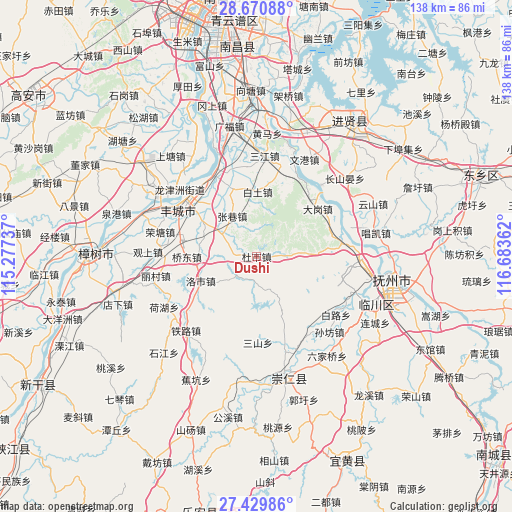
Dushi GPS coordinates[2]
28° 3' 7.776" North, 115° 58' 49.764" East
| Map corner | latitude | longitude |
|---|---|---|
| Upper-left | 28.67088°, | 115.27737° |
| Center: | 28.05216°, | 115.98049° |
| Lower-right: | 27.42986°, | 116.68362° |
| Map W x H: | 138×138 km | = 85.7×85.7mi |
| max Lat: | 53.31946° ⇑73.6% North |
| Dushi: | 28.05216° |
| min Lat: | ⇓26.4% South 18.22056° |
| min Long | Dushi | max Long |
| 75.07348° | 115.98049° | 134.28917° |
| W 59.9%⇐ | ⇒40.1% E |
Elevation
Elevation of Dushi is 41 m = 135 ft, and this is 443.8 m = 1456 ft below average elevation for this country.
| Max E: |
5622 m = 18445 ft | 73.3% |
| Avg. | 484.8 m = 1591 ft | |
| Dushi | 41 m = 135 ft | |
Min E: |
-3 m = -10 ft | 26.7% |
See also: China elevation on elevation.city.
Geographical zone
Dushi is located in North temperate zone (between Tropic of Cancer and the Arctic Circle). Distance of this Northern Tropic circle is 513.2 km =318.9 mi to South.| Distance of | km | miles | from Dushi |
|---|---|---|---|
| North Pole | 6888 | 4280 | to North |
| Arctic Circle | 4282.1 | 2660.8 | to North |
| Tropic Cancer | 513.2 | 318.9 | to South |
| Equator | 3119.1 | 1938.1 | to South |


Nearby cities:
15 places around Dushi: (largest is in red/bold)
• Baitu
17.3 km =10.7 mi,  1°
1°
• Dagang
22 km =13.7 mi,  58°
58°
• Duantan
24.2 km =15 mi,  353°
353°
• Gaoping
22.1 km =13.7 mi,  129°
129°
• Heshang
21 km =13 mi,  170°
170°
• Luoshi
16.2 km =10.1 mi,  245°
245°
• Qiaodong
15.8 km =9.8 mi,  272°
272°
• Sanshan
23.4 km =14.5 mi,  178°
178°
• Shitan
16.4 km =10.2 mi,  301°
301°
• Sundu
23.3 km =14.5 mi,  294°
294°
• Taosha
8.5 km =5.3 mi,  90°
90°
• Tongyuan
23.9 km =14.9 mi,  82°
82°
• Xiaotang
18.6 km =11.6 mi,  338°
338°
• Xiushi
7.8 km =4.8 mi,  222°
222°
• Zhangxiang
12.7 km =7.9 mi,  328°
328°
Sources, notices
• [Note1] Compared only with cities in China existing in our database
• [Src1] Map data: © OpenStreetMap contributors (CC-BY-SA)
• [Src2] Other city data from geonames.org with taken over terms of usage.
• [Src3] Geographical zone / Annual Mean Temperature by Robert A. Rohde @ Wikipedia
