Luoshi geodata
Luoshi (Jiangxi) is a seat of a fourth-order administrative division; located in China in Asia/Shanghai (GMT+8) time zone. In our database, there are 1268 cities with bigger population. Compared to other cities in China, 74.2% of cities are located further ↑North; 59.1% of cities are located further ←West and 74.8% of cities have higher elevation than Luoshi. Note1


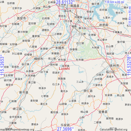
Luoshi GPS coordinates[2]
27° 59' 32.1" North, 115° 49' 46.74" East
| Map corner | latitude | longitude |
|---|---|---|
| Upper-left | 28.61132°, | 115.12653° |
| Center: | 27.99225°, | 115.82965° |
| Lower-right: | 27.3696°, | 116.53278° |
| Map W x H: | 138.1×138.1 km | = 85.8×85.8mi |
| max Lat: | 53.31946° ⇑74.2% North |
| Luoshi: | 27.99225° |
| min Lat: | ⇓25.8% South 18.22056° |
| min Long | Luoshi | max Long |
| 75.07348° | 115.82965° | 134.28917° |
| W 59.1%⇐ | ⇒40.9% E |
Elevation
Elevation of Luoshi is 37 m = 121 ft, and this is 447.8 m = 1469 ft below average elevation for this country.
| Max E: |
5622 m = 18445 ft | 74.8% |
| Avg. | 484.8 m = 1591 ft | |
| Luoshi | 37 m = 121 ft | |
Min E: |
-3 m = -10 ft | 25.2% |
See also: China elevation on elevation.city.
Geographical zone
Luoshi is located in North temperate zone (between Tropic of Cancer and the Arctic Circle). Distance of this Northern Tropic circle is 506.5 km =314.7 mi to South.| Distance of | km | miles | from Luoshi |
|---|---|---|---|
| North Pole | 6894.6 | 4284.1 | to North |
| Arctic Circle | 4288.7 | 2664.9 | to North |
| Tropic Cancer | 506.5 | 314.7 | to South |
| Equator | 3112.4 | 1934 | to South |


Nearby cities:
15 places around Luoshi: (largest is in red/bold)
• Baibei
22.3 km =13.9 mi,  159°
159°
• Dushi
16.2 km =10.1 mi,  65°
65°
• Hehu
12.6 km =7.8 mi,  235°
235°
• Jianguang
22.9 km =14.2 mi,  348°
348°
• Licun
12.8 km =8 mi,  271°
271°
• Qiaodong
7.4 km =4.6 mi, 352°
• Rongtang
17.1 km =10.6 mi,  319°
319°
• Sanshan
22.8 km =14.2 mi,  137°
137°
• Shijiang
21.6 km =13.4 mi,  208°
208°
• Shitan
15.3 km =9.5 mi,  3°
3°
• Sundu
17.6 km =10.9 mi,  338°
338°
• Tielu
13.9 km =8.6 mi,  197°
197°
• Xiushi
9.6 km =6 mi,  84°
84°
• Xiwang
16.5 km =10.3 mi,  228°
228°
• Zhangxiang
19.3 km =12 mi,  25°
25°
Sources, notices
• [Note1] Compared only with cities in China existing in our database
• [Src1] Map data: © OpenStreetMap contributors (CC-BY-SA)
• [Src2] Other city data from geonames.org with taken over terms of usage.
• [Src3] Geographical zone / Annual Mean Temperature by Robert A. Rohde @ Wikipedia
