Duoba geodata
Duoba (Qinghai) is a seat of a fourth-order administrative division; located in China in Asia/Shanghai (GMT+8) time zone. In our database, there are 1268 cities with bigger population. Compared to other cities in China, 78.5% of cities are located further ↓South; 93.4% of cities are located further →East and 95.6% of cities have lower elevation than Duoba. Note1


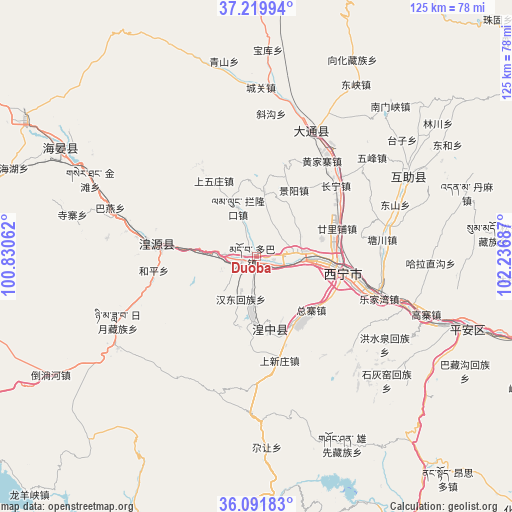
Duoba GPS coordinates[2]
36° 39' 28.62" North, 101° 32' 1.464" East
| Map corner | latitude | longitude |
|---|---|---|
| Upper-left | 37.21994°, | 100.83062° |
| Center: | 36.65795°, | 101.53374° |
| Lower-right: | 36.09183°, | 102.23687° |
| Map W x H: | 125.4×125.4 km | = 77.9×77.9mi |
| max Lat: | 53.31946° ⇑21.5% North |
| Duoba: | 36.65795° |
| min Lat: | ⇓78.5% South 18.22056° |
| min Long | Duoba | max Long |
| 75.07348° | 101.53374° | 134.28917° |
| W 6.6%⇐ | ⇒93.4% E |
Elevation
Elevation of Duoba is 2371 m = 7779 ft, and this is 1886.2 m = 6188 ft above average elevation for this country.
| Max E: |
5622 m = 18445 ft | 4.4% |
| Duoba | 2371 m 7779 ft | |
| Avg. | 484.8 m = 1591 ft | |
Min E: |
-3 m = -10 ft | 95.6% |
See also: China elevation on elevation.city.
Geographical zone
Duoba is located in North temperate zone (between Tropic of Cancer and the Arctic Circle). Distance of this Northern Tropic circle is 1470.1 km =913.5 mi to South.| Distance of | km | miles | from Duoba |
|---|---|---|---|
| North Pole | 5931.1 | 3685.4 | to North |
| Arctic Circle | 3325.2 | 2066.2 | to North |
| Tropic Cancer | 1470.1 | 913.5 | to South |
| Equator | 4076 | 2532.7 | to South |


Nearby cities:
15 places around Duoba: (largest is in red/bold)
• Beihe
12.1 km =7.5 mi,  231°
231°
• Changning
26.5 km =16.5 mi,  44°
44°
• Dongxia
18.7 km =11.6 mi,  278°
278°
• Ershilipu
20.4 km =12.7 mi,  73°
73°
• Ganhetan
17.5 km =10.9 mi,  188°
188°
• Haizigou
10.8 km =6.7 mi,  59°
59°
• Heping
26.3 km =16.3 mi,  264°
264°
• Huangyuan Chengguanzhen
23.7 km =14.7 mi, 277°
• Jingyang
20.6 km =12.8 mi,  30°
30°
• Lanlongkou
13.4 km =8.3 mi,  336°
336°
• Lijiashan
15.7 km =9.8 mi,  5°
5°
• Lushar
19.5 km =12.1 mi,  172°
172°
• Shangwuzhuang
24 km =14.9 mi, 335°
• Xining
20.3 km =12.6 mi,  100°
100°
• Zongzhai
21.1 km =13.1 mi,  132°
132°
Sources, notices
• [Note1] Compared only with cities in China existing in our database
• [Src1] Map data: © OpenStreetMap contributors (CC-BY-SA)
• [Src2] Other city data from geonames.org with taken over terms of usage.
• [Src3] Geographical zone / Annual Mean Temperature by Robert A. Rohde @ Wikipedia
