Ershilipu geodata
Ershilipu (Qinghai) is a seat of a fourth-order administrative division; located in China in Asia/Shanghai (GMT+8) time zone. In our database, there are 1268 cities with bigger population. Compared to other cities in China, 78.6% of cities are located further ↓South; 93.1% of cities are located further →East and 95.5% of cities have lower elevation than Ershilipu. Note1


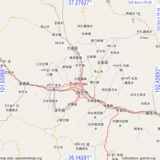
Ershilipu GPS coordinates[2]
36° 42' 31.176" North, 101° 45' 13.68" East
| Map corner | latitude | longitude |
|---|---|---|
| Upper-left | 37.27027°, | 101.05068° |
| Center: | 36.70866°, | 101.7538° |
| Lower-right: | 36.14291°, | 102.45693° |
| Map W x H: | 125.4×125.4 km | = 77.9×77.9mi |
| max Lat: | 53.31946° ⇑21.4% North |
| Ershilipu: | 36.70866° |
| min Lat: | ⇓78.6% South 18.22056° |
| min Long | Ershilipu | max Long |
| 75.07348° | 101.7538° | 134.28917° |
| W 6.9%⇐ | ⇒93.1% E |
Elevation
Elevation of Ershilipu is 2310 m = 7579 ft, and this is 1825.2 m = 5988 ft above average elevation for this country.
| Max E: |
5622 m = 18445 ft | 4.5% |
| Ershilipu | 2310 m 7579 ft | |
| Avg. | 484.8 m = 1591 ft | |
Min E: |
-3 m = -10 ft | 95.5% |
See also: China elevation on elevation.city.
Geographical zone
Ershilipu is located in North temperate zone (between Tropic of Cancer and the Arctic Circle). Distance of this Northern Tropic circle is 1475.7 km =917 mi to South.| Distance of | km | miles | from Ershilipu |
|---|---|---|---|
| North Pole | 5925.4 | 3681.9 | to North |
| Arctic Circle | 3319.6 | 2062.7 | to North |
| Tropic Cancer | 1475.7 | 917 | to South |
| Equator | 4081.6 | 2536.2 | to South |


Nearby cities:
15 places around Ershilipu: (largest is in red/bold)
• Changning
13.5 km =8.4 mi,  354°
354°
• Duoba
20.4 km =12.7 mi,  253°
253°
• Gaozhai
27.7 km =17.2 mi,  131°
131°
• Haizigou
10.3 km =6.4 mi,  268°
268°
• Huangjiazhai
18.1 km =11.2 mi, 348°
• Jingyang
15.1 km =9.4 mi,  322°
322°
• Lanlongkou
25.8 km =16 mi,  285°
285°
• Lijiashan
20.7 km =12.9 mi,  298°
298°
• Qiaotou
26.2 km =16.3 mi,  344°
344°
• Weiyuan
26.6 km =16.5 mi,  52°
52°
• Wufeng
20.1 km =12.5 mi,  25°
25°
• Xiaoxia
27.5 km =17.1 mi,  136°
136°
• Xining
9.2 km =5.7 mi,  178°
178°
• Xishan
11.3 km =7 mi, 48°
• Zongzhai
20.4 km =12.7 mi,  191°
191°
Sources, notices
• [Note1] Compared only with cities in China existing in our database
• [Src1] Map data: © OpenStreetMap contributors (CC-BY-SA)
• [Src2] Other city data from geonames.org with taken over terms of usage.
• [Src3] Geographical zone / Annual Mean Temperature by Robert A. Rohde @ Wikipedia
