Dongzhu geodata
Dongzhu (Jiangsu) is a seat of a fourth-order administrative division; located in China in Asia/Shanghai (GMT+8) time zone. In our database, there are 1268 cities with bigger population. Compared to other cities in China, 57.3% of cities are located further ↓South; 84.5% of cities are located further ←West and 97.2% of cities have higher elevation than Dongzhu. Note1


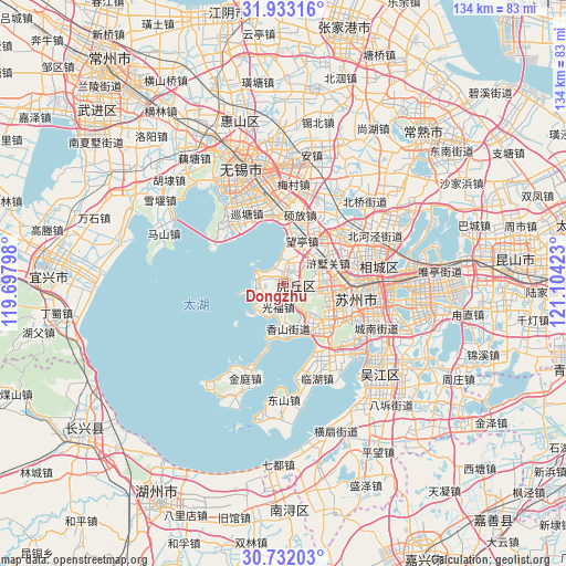
Dongzhu GPS coordinates[2]
31° 20' 4.236" North, 120° 24' 3.96" East
| Map corner | latitude | longitude |
|---|---|---|
| Upper-left | 31.93316°, | 119.69798° |
| Center: | 31.33451°, | 120.4011° |
| Lower-right: | 30.73203°, | 121.10423° |
| Map W x H: | 133.6×133.6 km | = 83×83mi |
| max Lat: | 53.31946° ⇑42.7% North |
| Dongzhu: | 31.33451° |
| min Lat: | ⇓57.3% South 18.22056° |
| min Long | Dongzhu | max Long |
| 75.07348° | 120.4011° | 134.28917° |
| W 84.5%⇐ | ⇒15.5% E |
Elevation
Elevation of Dongzhu is 5 m = 16 ft, and this is 479.8 m = 1574 ft below average elevation for this country.
| Max E: |
5622 m = 18445 ft | 97.2% |
| Avg. | 484.8 m = 1591 ft | |
| Dongzhu | 5 m = 16 ft | |
Min E: |
-3 m = -10 ft | 2.8% |
See also: China elevation on elevation.city.
Geographical zone
Dongzhu is located in North temperate zone (between Tropic of Cancer and the Arctic Circle). Distance of this Northern Tropic circle is 878.2 km =545.7 mi to South.| Distance of | km | miles | from Dongzhu |
|---|---|---|---|
| North Pole | 6523 | 4053.2 | to North |
| Arctic Circle | 3917.1 | 2434 | to North |
| Tropic Cancer | 878.2 | 545.7 | to South |
| Equator | 3484.1 | 2164.9 | to South |


Nearby cities:
15 places around Dongzhu: (largest is in red/bold)
• Baiyangwan
13.5 km =8.4 mi,  83°
83°
• Binhu
17.3 km =10.7 mi,  309°
309°
• Fengqiao
14.1 km =8.8 mi,  99°
99°
• Guangfu
5.3 km =3.3 mi,  192°
192°
• Huangdai
18.6 km =11.6 mi,  52°
52°
• Huazhuang
17.4 km =10.8 mi,  341°
341°
• Mudu
14.2 km =8.8 mi,  128°
128°
• Shilu
18.5 km =11.5 mi, 97°
• Shishan
16.1 km =10 mi, 104°
• Shuofang
17.5 km =10.9 mi,  12°
12°
• Tong’an
6.6 km =4.1 mi, 46°
• Wangting
12.3 km =7.6 mi,  17°
17°
• Xiangshan
11.4 km =7.1 mi,  181°
181°
• Xukou
13.3 km =8.3 mi,  147°
147°
• Xushuguan
10.5 km =6.5 mi,  61°
61°
Sources, notices
• [Note1] Compared only with cities in China existing in our database
• [Src1] Map data: © OpenStreetMap contributors (CC-BY-SA)
• [Src2] Other city data from geonames.org with taken over terms of usage.
• [Src3] Geographical zone / Annual Mean Temperature by Robert A. Rohde @ Wikipedia
