Mudu geodata
Mudu (Jiangsu) is a seat of a fourth-order administrative division; located in China in Asia/Shanghai (GMT+8) time zone. With population of 61,902 people, there are 701 cities with bigger population in this country. Compared to other cities in China, 56.7% of cities are located further ↓South; 85.1% of cities are located further ←West and 91.2% of cities have higher elevation than Mudu. Note1


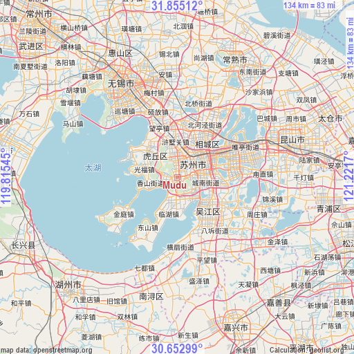
Mudu GPS coordinates[2]
31° 15' 21.492" North, 120° 31' 6.852" East
| Map corner | latitude | longitude |
|---|---|---|
| Upper-left | 31.85512°, | 119.81545° |
| Center: | 31.25597°, | 120.51857° |
| Lower-right: | 30.65299°, | 121.2217° |
| Map W x H: | 133.7×133.7 km | = 83.1×83.1mi |
| max Lat: | 53.31946° ⇑43.3% North |
| Mudu: | 31.25597° |
| min Lat: | ⇓56.7% South 18.22056° |
| min Long | Mudu | max Long |
| 75.07348° | 120.51857° | 134.28917° |
| W 85.1%⇐ | ⇒14.9% E |
Elevation
Elevation of Mudu is 9 m = 30 ft, and this is 475.8 m = 1561 ft below average elevation for this country.
| Max E: |
5622 m = 18445 ft | 91.2% |
| Avg. | 484.8 m = 1591 ft | |
| Mudu | 9 m = 30 ft | |
Min E: |
-3 m = -10 ft | 8.8% |
See also: Mudu elevation on elevation.city.
Geographical zone
Mudu is located in North temperate zone (between Tropic of Cancer and the Arctic Circle). Distance of this Northern Tropic circle is 869.4 km =540.2 mi to South.| Distance of | km | miles | from Mudu |
|---|---|---|---|
| North Pole | 6531.7 | 4058.6 | to North |
| Arctic Circle | 3925.8 | 2439.4 | to North |
| Tropic Cancer | 869.4 | 540.2 | to South |
| Equator | 3475.3 | 2159.5 | to South |


Nearby cities:
15 places around Mudu: (largest is in red/bold)
• Baiyangwan
10.5 km =6.5 mi,  12°
12°
• Dongzhu
14.2 km =8.8 mi,  308°
308°
• Fengqiao
7 km =4.3 mi,  23°
23°
• Guangfu
12.8 km =8 mi,  286°
286°
• Hengjing
9.4 km =5.8 mi,  172°
172°
• Loufeng
13.9 km =8.6 mi,  73°
73°
• Pingjianglu
12.4 km =7.7 mi,  58°
58°
• Shilu
9.5 km =5.9 mi,  49°
49°
• Shishan
6.5 km =4 mi,  42°
42°
• Shuangta
11.8 km =7.3 mi, 63°
• Suzhou
9 km =5.6 mi, 53°
• Xiangshan
11.8 km =7.3 mi,  257°
257°
• Xukou
4.6 km =2.9 mi,  238°
238°
• Xushuguan
14 km =8.7 mi,  352°
352°
• Yuexi
7.7 km =4.8 mi,  125°
125°
Sources, notices
• [Note1] Compared only with cities in China existing in our database
• [Src1] Map data: © OpenStreetMap contributors (CC-BY-SA)
• [Src2] Other city data from geonames.org with taken over terms of usage.
• [Src3] Geographical zone / Annual Mean Temperature by Robert A. Rohde @ Wikipedia
