Dongsha geodata
Dongsha (Zhejiang) is a seat of a fourth-order administrative division; located in China in Asia/Shanghai (GMT+8) time zone. In our database, there are 1268 cities with bigger population. Compared to other cities in China, 51.1% of cities are located further ↑North; 91.4% of cities are located further ←West and 98.9% of cities have higher elevation than Dongsha. Note1


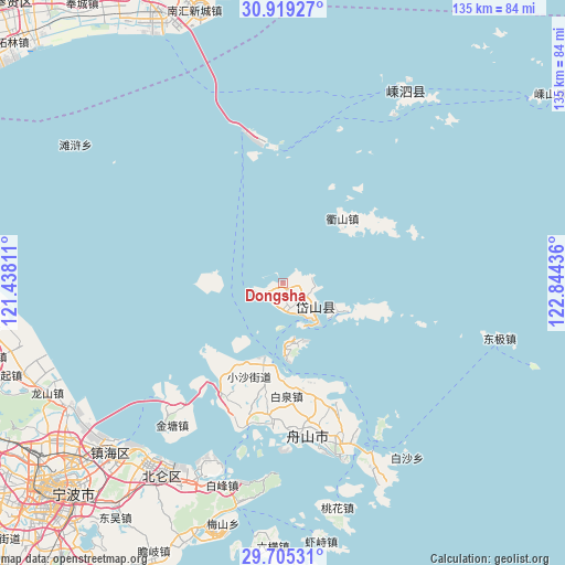
Dongsha GPS coordinates[2]
30° 18' 51.012" North, 122° 8' 28.428" East
| Map corner | latitude | longitude |
|---|---|---|
| Upper-left | 30.91927°, | 121.43811° |
| Center: | 30.31417°, | 122.14123° |
| Lower-right: | 29.70531°, | 122.84436° |
| Map W x H: | 135×135 km | = 83.9×83.9mi |
| max Lat: | 53.31946° ⇑51.1% North |
| Dongsha: | 30.31417° |
| min Lat: | ⇓48.9% South 18.22056° |
| min Long | Dongsha | max Long |
| 75.07348° | 122.14123° | 134.28917° |
| W 91.4%⇐ | ⇒8.6% E |
Elevation
Elevation of Dongsha is 3 m = 10 ft, and this is 481.8 m = 1581 ft below average elevation for this country.
| Max E: |
5622 m = 18445 ft | 98.9% |
| Avg. | 484.8 m = 1591 ft | |
| Dongsha | 3 m = 10 ft | |
Min E: |
-3 m = -10 ft | 1.1% |
See also: China elevation on elevation.city.
Geographical zone
Dongsha is located in North temperate zone (between Tropic of Cancer and the Arctic Circle). Distance of this Northern Tropic circle is 764.7 km =475.2 mi to South.| Distance of | km | miles | from Dongsha |
|---|---|---|---|
| North Pole | 6636.4 | 4123.7 | to North |
| Arctic Circle | 4030.6 | 2504.5 | to North |
| Tropic Cancer | 764.7 | 475.2 | to South |
| Equator | 3370.6 | 2094.4 | to South |


Nearby cities:
15 places around Dongsha: (largest is in red/bold)
• Baiquan
27 km =16.8 mi,  178°
178°
• Beichan
28.5 km =17.7 mi,  164°
164°
• Cengang
29.8 km =18.5 mi,  207°
207°
• Changtu
16.9 km =10.5 mi,  113°
113°
• Daidaon
5.8 km =3.6 mi, 111°
• Daishan
9.4 km =5.8 mi,  143°
143°
• Daixi
2.9 km =1.8 mi,  217°
217°
• Ganlan
23.5 km =14.6 mi, 180°
• Ma’ao
22.9 km =14.2 mi,  193°
193°
• Nizhi
3.5 km =2.2 mi, 108°
• Qushan
20.4 km =12.7 mi,  42°
42°
• Shadili
18.3 km =11.4 mi, 212°
• Shuangqiao
31 km =19.3 mi,  203°
203°
• Xiaosha
24.3 km =15.1 mi, 199°
• Xiushan
14.1 km =8.8 mi,  169°
169°
Sources, notices
• [Note1] Compared only with cities in China existing in our database
• [Src1] Map data: © OpenStreetMap contributors (CC-BY-SA)
• [Src2] Other city data from geonames.org with taken over terms of usage.
• [Src3] Geographical zone / Annual Mean Temperature by Robert A. Rohde @ Wikipedia
