Ma’ao geodata
Ma’ao (Zhejiang) is a seat of a fourth-order administrative division; located in China in Asia/Shanghai (GMT+8) time zone. In our database, there are 1268 cities with bigger population. Compared to other cities in China, 52.9% of cities are located further ↑North; 91.3% of cities are located further ←West and 86.9% of cities have higher elevation than Ma’ao. Note1


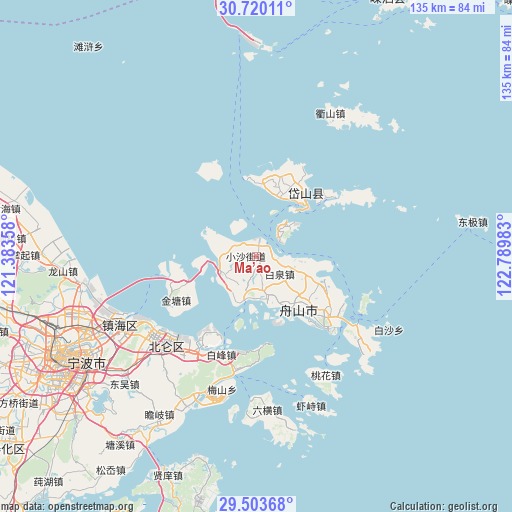
Ma’ao GPS coordinates[2]
30° 6' 49.572" North, 122° 5' 12.12" East
| Map corner | latitude | longitude |
|---|---|---|
| Upper-left | 30.72011°, | 121.38358° |
| Center: | 30.11377°, | 122.0867° |
| Lower-right: | 29.50368°, | 122.78983° |
| Map W x H: | 135.3×135.3 km | = 84.1×84.1mi |
| max Lat: | 53.31946° ⇑52.9% North |
| Ma’ao: | 30.11377° |
| min Lat: | ⇓47.1% South 18.22056° |
| min Long | Ma’ao | max Long |
| 75.07348° | 122.0867° | 134.28917° |
| W 91.3%⇐ | ⇒8.7% E |
Elevation
Elevation of Ma’ao is 13 m = 43 ft, and this is 471.8 m = 1548 ft below average elevation for this country.
| Max E: |
5622 m = 18445 ft | 86.9% |
| Avg. | 484.8 m = 1591 ft | |
| Ma’ao | 13 m = 43 ft | |
Min E: |
-3 m = -10 ft | 13.1% |
See also: China elevation on elevation.city.
Geographical zone
Ma’ao is located in North temperate zone (between Tropic of Cancer and the Arctic Circle). Distance of this Northern Tropic circle is 742.4 km =461.3 mi to South.| Distance of | km | miles | from Ma’ao |
|---|---|---|---|
| North Pole | 6658.7 | 4137.5 | to North |
| Arctic Circle | 4052.8 | 2518.3 | to North |
| Tropic Cancer | 742.4 | 461.3 | to South |
| Equator | 3348.3 | 2080.5 | to South |


Nearby cities:
15 places around Ma’ao: (largest is in red/bold)
• Baiquan
7.8 km =4.8 mi,  127°
127°
• Beichan
13.8 km =8.6 mi,  112°
112°
• Cengang
9.6 km =6 mi,  245°
245°
• Cezi
15.2 km =9.4 mi,  257°
257°
• Daishan
18.2 km =11.3 mi,  36°
36°
• Daixi
20.3 km =12.6 mi,  9°
9°
• Ganlan
5 km =3.1 mi,  104°
104°
• Lincheng
17 km =10.6 mi,  140°
140°
• Shadili
8.2 km =5.1 mi,  326°
326°
• Shuangqiao
9.5 km =5.9 mi,  229°
229°
• Xiaosha
2.9 km =1.8 mi, 256°
• Xiushan
11.5 km =7.1 mi, 43°
• Yancang
9.4 km =5.8 mi,  197°
197°
• Zhanmao
21.2 km =13.2 mi,  117°
117°
• Zhoushan
18 km =11.2 mi, 140°
Sources, notices
• [Note1] Compared only with cities in China existing in our database
• [Src1] Map data: © OpenStreetMap contributors (CC-BY-SA)
• [Src2] Other city data from geonames.org with taken over terms of usage.
• [Src3] Geographical zone / Annual Mean Temperature by Robert A. Rohde @ Wikipedia
