Dingcheng geodata
Dingcheng (Hainan) is a seat of a third-order administrative division; located in China in Asia/Shanghai (GMT+8) time zone. In our database, there are 1268 cities with bigger population. Compared to other cities in China, 99.1% of cities are located further ↑North; 69.7% of cities are located further →East and 73.3% of cities have higher elevation than Dingcheng. Note1


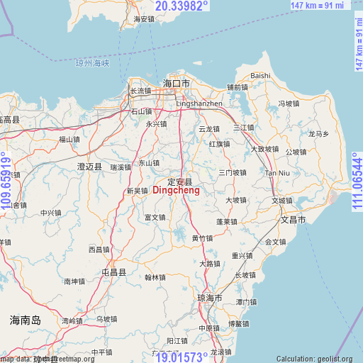
Dingcheng GPS coordinates[2]
19° 40' 44.904" North, 110° 21' 44.316" East
| Map corner | latitude | longitude |
|---|---|---|
| Upper-left | 20.33982°, | 109.65919° |
| Center: | 19.67914°, | 110.36231° |
| Lower-right: | 19.01573°, | 111.06544° |
| Map W x H: | 147.2×147.2 km | = 91.5×91.5mi |
| max Lat: | 53.31946° ⇑99.1% North |
| Dingcheng: | 19.67914° |
| min Lat: | ⇓0.9% South 18.22056° |
| min Long | Dingcheng | max Long |
| 75.07348° | 110.36231° | 134.28917° |
| W 30.3%⇐ | ⇒69.7% E |
Elevation
Elevation of Dingcheng is 41 m = 135 ft, and this is 443.8 m = 1456 ft below average elevation for this country.
| Max E: |
5622 m = 18445 ft | 73.3% |
| Avg. | 484.8 m = 1591 ft | |
| Dingcheng | 41 m = 135 ft | |
Min E: |
-3 m = -10 ft | 26.7% |
See also: China elevation on elevation.city.
Geographical zone
Dingcheng is located in North Torrid zone (between Equator and Tropic of Cancer). Distance of this Northern Tropic circle is 417.8 km =259.6 mi to North.| Distance of | km | miles | from Dingcheng |
|---|---|---|---|
| North Pole | 7818.9 | 4858.4 | to North |
| Arctic Circle | 5213.1 | 3239.3 | to North |
| Tropic Cancer | 417.8 | 259.6 | to North |
| Equator | 2188.1 | 1359.6 | to South |


Nearby cities:
15 places around Dingcheng: (largest is in red/bold)
• Dapo
23 km =14.3 mi,  107°
107°
• Dongshan
15.8 km =9.8 mi,  300°
300°
• Fuwen
18.1 km =11.2 mi,  218°
218°
• Hongqi
21.8 km =13.5 mi,  43°
43°
• Jiazi
15.8 km =9.8 mi,  119°
119°
• Jiuzhou
11.2 km =7 mi,  23°
23°
• Leiming
14.3 km =8.9 mi,  198°
198°
• Longhu
11.8 km =7.3 mi,  163°
163°
• Longtang
23.4 km =14.5 mi,  12°
12°
• Sanmenpo
20.9 km =13 mi,  78°
78°
• Xinpo
10.3 km =6.4 mi,  1°
1°
• Xinwu
18.6 km =11.6 mi,  259°
259°
• Xinzhu
17.5 km =10.9 mi,  248°
248°
• Yongfa
19.1 km =11.9 mi,  293°
293°
• Zuntan
16.4 km =10.2 mi,  336°
336°
Sources, notices
• [Note1] Compared only with cities in China existing in our database
• [Src1] Map data: © OpenStreetMap contributors (CC-BY-SA)
• [Src2] Other city data from geonames.org with taken over terms of usage.
• [Src3] Geographical zone / Annual Mean Temperature by Robert A. Rohde @ Wikipedia
