Yongfa geodata
Yongfa (Hainan) is a seat of a fourth-order administrative division; located in China in Asia/Shanghai (GMT+8) time zone. In our database, there are 1268 cities with bigger population. Compared to other cities in China, 99% of cities are located further ↑North; 70.4% of cities are located further →East and 79.8% of cities have higher elevation than Yongfa. Note1


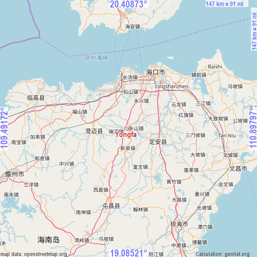
Yongfa GPS coordinates[2]
19° 44' 54.024" North, 110° 11' 41.424" East
| Map corner | latitude | longitude |
|---|---|---|
| Upper-left | 20.40873°, | 109.49172° |
| Center: | 19.74834°, | 110.19484° |
| Lower-right: | 19.08521°, | 110.89797° |
| Map W x H: | 147.2×147.2 km | = 91.5×91.5mi |
| max Lat: | 53.31946° ⇑99% North |
| Yongfa: | 19.74834° |
| min Lat: | ⇓1% South 18.22056° |
| min Long | Yongfa | max Long |
| 75.07348° | 110.19484° | 134.28917° |
| W 29.6%⇐ | ⇒70.4% E |
Elevation
Elevation of Yongfa is 27 m = 89 ft, and this is 457.8 m = 1502 ft below average elevation for this country.
| Max E: |
5622 m = 18445 ft | 79.8% |
| Avg. | 484.8 m = 1591 ft | |
| Yongfa | 27 m = 89 ft | |
Min E: |
-3 m = -10 ft | 20.2% |
See also: China elevation on elevation.city.
Geographical zone
Yongfa is located in North Torrid zone (between Equator and Tropic of Cancer). Distance of this Northern Tropic circle is 410.1 km =254.8 mi to North.| Distance of | km | miles | from Yongfa |
|---|---|---|---|
| North Pole | 7811.3 | 4853.7 | to North |
| Arctic Circle | 5205.4 | 3234.5 | to North |
| Tropic Cancer | 410.1 | 254.8 | to North |
| Equator | 2195.8 | 1364.4 | to South |


Nearby cities:
15 places around Yongfa: (largest is in red/bold)
• Dingcheng
19.1 km =11.9 mi,  113°
113°
• Dongshan
4 km =2.5 mi,  84°
84°
• Fuwen
22.8 km =14.2 mi,  163°
163°
• Jinjiang
19.6 km =12.2 mi,  263°
263°
• Jiuzhou
22.2 km =13.8 mi, 83°
• Leiming
25 km =15.5 mi,  148°
148°
• Longqiao
24.9 km =15.5 mi,  42°
42°
• Mei’an
14.5 km =9 mi,  356°
356°
• Ruixi
7.5 km =4.7 mi, 258°
• Shishan
20.8 km =12.9 mi,  2°
2°
• Xinpo
18 km =11.2 mi, 81°
• Xinwu
11 km =6.8 mi,  184°
184°
• Xinzhu
14.1 km =8.8 mi, 175°
• Yongxing
17.7 km =11 mi,  23°
23°
• Zuntan
13.2 km =8.2 mi,  56°
56°
Sources, notices
• [Note1] Compared only with cities in China existing in our database
• [Src1] Map data: © OpenStreetMap contributors (CC-BY-SA)
• [Src2] Other city data from geonames.org with taken over terms of usage.
• [Src3] Geographical zone / Annual Mean Temperature by Robert A. Rohde @ Wikipedia
