Dayou geodata
Dayou (Jiangsu) is a seat of a fourth-order administrative division; located in China in Asia/Shanghai (GMT+8) time zone. In our database, there are 1268 cities with bigger population. Compared to other cities in China, 71.2% of cities are located further ↓South; 81.1% of cities are located further ←West and 99.4% of cities have higher elevation than Dayou. Note1


Dayou GPS coordinates[2]
34° 13' 14.016" North, 119° 52' 51.996" East
| Map corner | latitude | longitude |
|---|---|---|
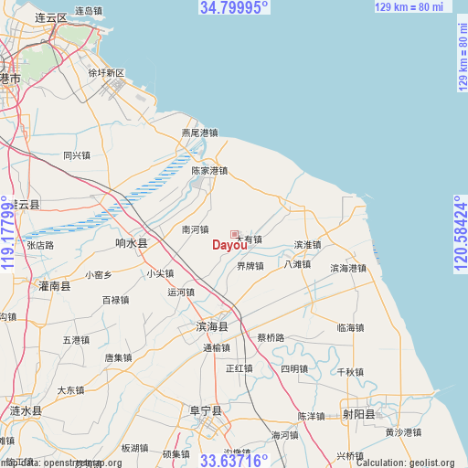
| Upper-left | 34.79995°, | 119.17799° |
| Center: | 34.22056°, | 119.88111° |
| Lower-right: | 33.63716°, | 120.58424° |
| Map W x H: | 129.3×129.3 km | = 80.3×80.3mi |
| max Lat: | 53.31946° ⇑28.8% North |
| Dayou: | 34.22056° |
| min Lat: | ⇓71.2% South 18.22056° |
| min Long | Dayou | max Long |
| 75.07348° | 119.88111° | 134.28917° |
| W 81.1%⇐ | ⇒18.9% E |
Elevation
Elevation of Dayou is 2 m = 7 ft, and this is 482.8 m = 1584 ft below average elevation for this country.
| Max E: |
5622 m = 18445 ft | 99.4% |
| Avg. | 484.8 m = 1591 ft | |
| Dayou | 2 m = 7 ft | |
Min E: |
-3 m = -10 ft | 0.6% |
See also: China elevation on elevation.city.
Geographical zone
Dayou is located in North temperate zone (between Tropic of Cancer and the Arctic Circle). Distance of this Northern Tropic circle is 1199.1 km =745.1 mi to South.| Distance of | km | miles | from Dayou |
|---|---|---|---|
| North Pole | 6202.1 | 3853.8 | to North |
| Arctic Circle | 3596.2 | 2234.6 | to North |
| Tropic Cancer | 1199.1 | 745.1 | to South |
| Equator | 3805 | 2364.3 | to South |


Nearby cities:
15 places around Dayou: (largest is in red/bold)
• Baju
14.9 km =9.3 mi,  140°
140°
• Batan
19.1 km =11.9 mi,  116°
116°
• Changmao
28.1 km =17.5 mi,  269°
269°
• Chenjiagang
19 km =11.8 mi,  337°
337°
• Dongkan
25 km =15.5 mi,  190°
190°
• Duigougang
23.9 km =14.9 mi, 335°
• Liutao
14.4 km =8.9 mi,  213°
213°
• Nanhe
11 km =6.8 mi,  287°
287°
• Qitao
6.6 km =4.1 mi, 205°
• Shuanggang
20.4 km =12.7 mi,  284°
284°
• Tianlou
26 km =16.2 mi, 277°
• Wudui
19.8 km =12.3 mi,  302°
302°
• Xiaojian
23.4 km =14.5 mi,  245°
245°
• Yunhe
21.5 km =13.4 mi,  224°
224°
• Zhangji
28.5 km =17.7 mi,  228°
228°
Sources, notices
• [Note1] Compared only with cities in China existing in our database
• [Src1] Map data: © OpenStreetMap contributors (CC-BY-SA)
• [Src2] Other city data from geonames.org with taken over terms of usage.
• [Src3] Geographical zone / Annual Mean Temperature by Robert A. Rohde @ Wikipedia
