Dongkan geodata
Dongkan (Jiangsu) is a populated place; located in China in Asia/Shanghai (GMT+8) time zone. With population of 72,789 people, there are 587 cities with bigger population in this country. Compared to other cities in China, 70.1% of cities are located further ↓South; 80.8% of cities are located further ←West and 95.9% of cities have higher elevation than Dongkan. Note1


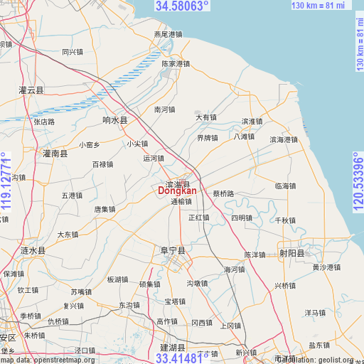
Dongkan GPS coordinates[2]
33° 59' 58.992" North, 119° 49' 50.988" East
| Map corner | latitude | longitude |
|---|---|---|
| Upper-left | 34.58063°, | 119.12771° |
| Center: | 33.99972°, | 119.83083° |
| Lower-right: | 33.41481°, | 120.53396° |
| Map W x H: | 129.6×129.6 km | = 80.5×80.5mi |
| max Lat: | 53.31946° ⇑29.9% North |
| Dongkan: | 33.99972° |
| min Lat: | ⇓70.1% South 18.22056° |
| min Long | Dongkan | max Long |
| 75.07348° | 119.83083° | 134.28917° |
| W 80.8%⇐ | ⇒19.2% E |
Elevation
Elevation of Dongkan is 6 m = 20 ft, and this is 478.8 m = 1571 ft below average elevation for this country.
| Max E: |
5622 m = 18445 ft | 95.9% |
| Avg. | 484.8 m = 1591 ft | |
| Dongkan | 6 m = 20 ft | |
Min E: |
-3 m = -10 ft | 4.1% |
See also: Dongkan elevation on elevation.city.
Geographical zone
Dongkan is located in North temperate zone (between Tropic of Cancer and the Arctic Circle). Distance of this Northern Tropic circle is 1174.5 km =729.8 mi to South.| Distance of | km | miles | from Dongkan |
|---|---|---|---|
| North Pole | 6226.6 | 3869 | to North |
| Arctic Circle | 3620.8 | 2249.9 | to North |
| Tropic Cancer | 1174.5 | 729.8 | to South |
| Equator | 3780.4 | 2349 | to South |


Nearby cities:
15 places around Dongkan: (largest is in red/bold)
• Bailu
29.1 km =18.1 mi,  281°
281°
• Baju
19.1 km =11.9 mi,  47°
47°
• Batan
26.9 km =16.7 mi, 53°
• Changmao
33.7 km =20.9 mi,  315°
315°
• Dayou
25 km =15.5 mi,  10°
10°
• Huayuan
36.1 km =22.4 mi, 283°
• Liutao
13 km =8.1 mi,  344°
344°
• Nanhe
28.4 km =17.6 mi,  348°
348°
• Qitao
18.6 km =11.6 mi, 5°
• Shuanggang
33.3 km =20.7 mi,  333°
333°
• Tianlou
35 km =21.7 mi, 322°
• Wudui
37.2 km =23.1 mi, 341°
• Xiaojian
22.3 km =13.9 mi,  311°
311°
• Yunhe
14 km =8.7 mi, 311°
• Zhangji
17.6 km =10.9 mi,  288°
288°
Sources, notices
• [Note1] Compared only with cities in China existing in our database
• [Src1] Map data: © OpenStreetMap contributors (CC-BY-SA)
• [Src2] Other city data from geonames.org with taken over terms of usage.
• [Src3] Geographical zone / Annual Mean Temperature by Robert A. Rohde @ Wikipedia
