Dawang geodata
Dawang (Shaanxi) is a seat of a fourth-order administrative division; located in China in Asia/Shanghai (GMT+8) time zone. In our database, there are 1268 cities with bigger population. Compared to other cities in China, 71.5% of cities are located further ↓South; 74% of cities are located further →East and 84.9% of cities have lower elevation than Dawang. Note1


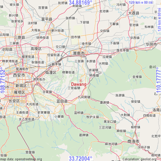
Dawang GPS coordinates[2]
34° 18' 10.332" North, 109° 28' 28.704" East
| Map corner | latitude | longitude |
|---|---|---|
| Upper-left | 34.88169°, | 108.77152° |
| Center: | 34.30287°, | 109.47464° |
| Lower-right: | 33.72004°, | 110.17777° |
| Map W x H: | 129.2×129.2 km | = 80.3×80.3mi |
| max Lat: | 53.31946° ⇑28.5% North |
| Dawang: | 34.30287° |
| min Lat: | ⇓71.5% South 18.22056° |
| min Long | Dawang | max Long |
| 75.07348° | 109.47464° | 134.28917° |
| W 26%⇐ | ⇒74% E |
Elevation
Elevation of Dawang is 977 m = 3205 ft, and this is 492.2 m = 1615 ft above average elevation for this country.
| Max E: |
5622 m = 18445 ft | 15.1% |
| Dawang | 977 m 3205 ft | |
| Avg. | 484.8 m = 1591 ft | |
Min E: |
-3 m = -10 ft | 84.9% |
See also: China elevation on elevation.city.
Geographical zone
Dawang is located in North temperate zone (between Tropic of Cancer and the Arctic Circle). Distance of this Northern Tropic circle is 1208.2 km =750.7 mi to South.| Distance of | km | miles | from Dawang |
|---|---|---|---|
| North Pole | 6192.9 | 3848.1 | to North |
| Arctic Circle | 3587.1 | 2228.9 | to North |
| Tropic Cancer | 1208.2 | 750.7 | to South |
| Equator | 3814.1 | 2370 | to South |


Nearby cities:
15 places around Dawang: (largest is in red/bold)
• Chongning
13.5 km =8.4 mi,  49°
49°
• Hexi
12.9 km =8 mi,  21°
21°
• Houzhen
5.7 km =3.5 mi,  147°
147°
• Jinshan
8.7 km =5.4 mi,  260°
260°
• Jiujianfang
13.5 km =8.4 mi,  164°
164°
• Ma’e
13.9 km =8.6 mi,  323°
323°
• Muzhai
12.1 km =7.5 mi,  305°
305°
• Qiaonan
11.7 km =7.3 mi,  67°
67°
• Sanguanmiao
7.6 km =4.7 mi,  225°
225°
• Tielu
10.5 km =6.5 mi,  344°
344°
• Tuqiao
15.3 km =9.5 mi,  290°
290°
• Xiaojin
6.9 km =4.3 mi, 305°
• Yancun
13 km =8.1 mi,  8°
8°
• Yangguo
7.2 km =4.5 mi,  35°
35°
• Yushan
11.1 km =6.9 mi,  167°
167°
Sources, notices
• [Note1] Compared only with cities in China existing in our database
• [Src1] Map data: © OpenStreetMap contributors (CC-BY-SA)
• [Src2] Other city data from geonames.org with taken over terms of usage.
• [Src3] Geographical zone / Annual Mean Temperature by Robert A. Rohde @ Wikipedia
