Muzhai geodata
Muzhai (Shaanxi) is a seat of a fourth-order administrative division; located in China in Asia/Shanghai (GMT+8) time zone. In our database, there are 1268 cities with bigger population. Compared to other cities in China, 71.9% of cities are located further ↓South; 74.6% of cities are located further →East and 82% of cities have lower elevation than Muzhai. Note1


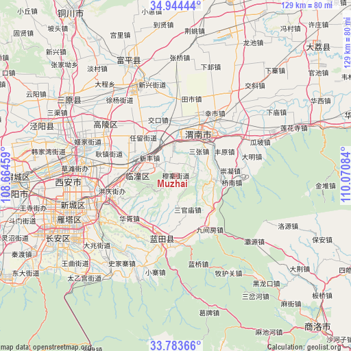
Muzhai GPS coordinates[2]
34° 21' 57.816" North, 109° 22' 3.756" East
| Map corner | latitude | longitude |
|---|---|---|
| Upper-left | 34.94444°, | 108.66459° |
| Center: | 34.36606°, | 109.36771° |
| Lower-right: | 33.78366°, | 110.07084° |
| Map W x H: | 129.1×129.1 km | = 80.2×80.2mi |
| max Lat: | 53.31946° ⇑28.1% North |
| Muzhai: | 34.36606° |
| min Lat: | ⇓71.9% South 18.22056° |
| min Long | Muzhai | max Long |
| 75.07348° | 109.36771° | 134.28917° |
| W 25.4%⇐ | ⇒74.6% E |
Elevation
Elevation of Muzhai is 792 m = 2598 ft, and this is 307.2 m = 1008 ft above average elevation for this country.
| Max E: |
5622 m = 18445 ft | 18% |
| Muzhai | 792 m 2598 ft | |
| Avg. | 484.8 m = 1591 ft | |
Min E: |
-3 m = -10 ft | 82% |
See also: China elevation on elevation.city.
Geographical zone
Muzhai is located in North temperate zone (between Tropic of Cancer and the Arctic Circle). Distance of this Northern Tropic circle is 1215.2 km =755.1 mi to South.| Distance of | km | miles | from Muzhai |
|---|---|---|---|
| North Pole | 6185.9 | 3843.7 | to North |
| Arctic Circle | 3580 | 2224.5 | to North |
| Tropic Cancer | 1215.2 | 755.1 | to South |
| Equator | 3821.1 | 2374.3 | to South |


Nearby cities:
15 places around Muzhai: (largest is in red/bold)
• Daiwang
7.6 km =4.7 mi,  296°
296°
• Dawang
12.1 km =7.5 mi,  125°
125°
• Jinshan
8.6 km =5.3 mi,  171°
171°
• Lingkou
12.4 km =7.7 mi,  357°
357°
• Lintong
14.6 km =9.1 mi,  275°
275°
• Ma’e
4.4 km =2.7 mi,  20°
20°
• Qinling Jieban
11.1 km =6.9 mi, 281°
• Sanguanmiao
13.1 km =8.1 mi,  160°
160°
• Sanzhang
12.4 km =7.7 mi,  43°
43°
• Tielu
7.6 km =4.7 mi,  65°
65°
• Tuqiao
4.8 km =3 mi,  250°
250°
• Xiaojin
5.1 km =3.2 mi, 125°
• Xinfeng
11.7 km =7.3 mi,  305°
305°
• Yancun
13.1 km =8.1 mi,  63°
63°
• Yangguo
14 km =8.7 mi,  94°
94°
Sources, notices
• [Note1] Compared only with cities in China existing in our database
• [Src1] Map data: © OpenStreetMap contributors (CC-BY-SA)
• [Src2] Other city data from geonames.org with taken over terms of usage.
• [Src3] Geographical zone / Annual Mean Temperature by Robert A. Rohde @ Wikipedia
