Daping geodata
Daping (Guangdong) is a seat of a fourth-order administrative division; located in China in Asia/Shanghai (GMT+8) time zone. In our database, there are 1268 cities with bigger population. Compared to other cities in China, 88.9% of cities are located further ↑North; 59.8% of cities are located further ←West and 58.3% of cities have lower elevation than Daping. Note1


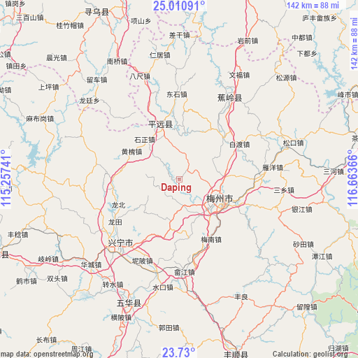
Daping GPS coordinates[2]
24° 22' 19.488" North, 115° 57' 37.908" East
| Map corner | latitude | longitude |
|---|---|---|
| Upper-left | 25.01091°, | 115.25741° |
| Center: | 24.37208°, | 115.96053° |
| Lower-right: | 23.73°, | 116.66366° |
| Map W x H: | 142.4×142.4 km | = 88.5×88.5mi |
| max Lat: | 53.31946° ⇑88.9% North |
| Daping: | 24.37208° |
| min Lat: | ⇓11.1% South 18.22056° |
| min Long | Daping | max Long |
| 75.07348° | 115.96053° | 134.28917° |
| W 59.8%⇐ | ⇒40.2% E |
Elevation
Elevation of Daping is 239 m = 784 ft, and this is 245.8 m = 806 ft below average elevation for this country.
| Max E: |
5622 m = 18445 ft | 41.7% |
| Avg. | 484.8 m = 1591 ft | |
| Daping | 239 m = 784 ft | |
Min E: |
-3 m = -10 ft | 58.3% |
See also: China elevation on elevation.city.
Geographical zone
Daping is located in North temperate zone (between Tropic of Cancer and the Arctic Circle). Distance of this Northern Tropic circle is 104 km =64.6 mi to South.| Distance of | km | miles | from Daping |
|---|---|---|---|
| North Pole | 7297.1 | 4534.2 | to North |
| Arctic Circle | 4691.3 | 2915 | to North |
| Tropic Cancer | 104 | 64.6 | to South |
| Equator | 2709.9 | 1683.9 | to South |


Nearby cities:
15 places around Daping: (largest is in red/bold)
• Changtian
10.9 km =6.8 mi,  2°
2°
• Chengbei
15 km =9.3 mi,  109°
109°
• Chengdong
18.1 km =11.2 mi,  87°
87°
• Chengjiang
16.4 km =10.2 mi,  128°
128°
• Jingxin
16.2 km =10.1 mi,  189°
189°
• Meixi
14.2 km =8.8 mi,  310°
310°
• Meixian
14.8 km =9.2 mi, 131°
• Meizhou
18.4 km =11.4 mi,  120°
120°
• Nankou
11.2 km =7 mi,  165°
165°
• Rezhe
18.3 km =11.4 mi,  6°
6°
• Shikeng
13.5 km =8.4 mi,  278°
278°
• Shima
16.7 km =10.4 mi,  235°
235°
• Shishan
15.2 km =9.4 mi,  56°
56°
• Xijiao
15.6 km =9.7 mi, 114°
• Yaoshang
7.2 km =4.5 mi,  205°
205°
Sources, notices
• [Note1] Compared only with cities in China existing in our database
• [Src1] Map data: © OpenStreetMap contributors (CC-BY-SA)
• [Src2] Other city data from geonames.org with taken over terms of usage.
• [Src3] Geographical zone / Annual Mean Temperature by Robert A. Rohde @ Wikipedia
