Jingxin geodata
Jingxin (Guangdong) is a seat of a fourth-order administrative division; located in China in Asia/Shanghai (GMT+8) time zone. In our database, there are 1268 cities with bigger population. Compared to other cities in China, 89.5% of cities are located further ↑North; 59.7% of cities are located further ←West and 60.6% of cities have lower elevation than Jingxin. Note1


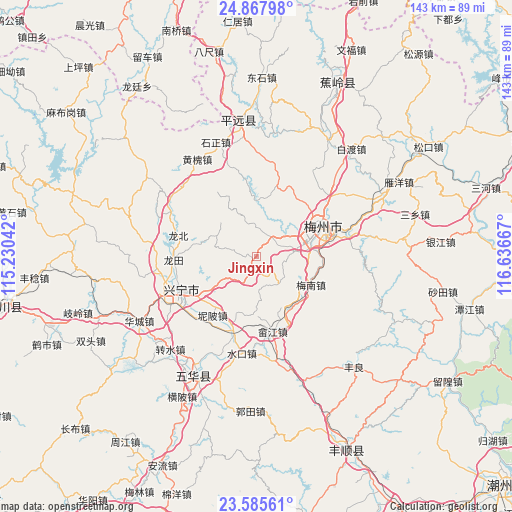
Jingxin GPS coordinates[2]
24° 13' 42.276" North, 115° 56' 0.744" East
| Map corner | latitude | longitude |
|---|---|---|
| Upper-left | 24.86798°, | 115.23042° |
| Center: | 24.22841°, | 115.93354° |
| Lower-right: | 23.58561°, | 116.63667° |
| Map W x H: | 142.6×142.6 km | = 88.6×88.6mi |
| max Lat: | 53.31946° ⇑89.5% North |
| Jingxin: | 24.22841° |
| min Lat: | ⇓10.5% South 18.22056° |
| min Long | Jingxin | max Long |
| 75.07348° | 115.93354° | 134.28917° |
| W 59.7%⇐ | ⇒40.3% E |
Elevation
Elevation of Jingxin is 267 m = 876 ft, and this is 217.8 m = 715 ft below average elevation for this country.
| Max E: |
5622 m = 18445 ft | 39.4% |
| Avg. | 484.8 m = 1591 ft | |
| Jingxin | 267 m = 876 ft | |
Min E: |
-3 m = -10 ft | 60.6% |
See also: China elevation on elevation.city.
Geographical zone
Jingxin is located in North temperate zone (between Tropic of Cancer and the Arctic Circle). Distance of this Northern Tropic circle is 88 km =54.7 mi to South.| Distance of | km | miles | from Jingxin |
|---|---|---|---|
| North Pole | 7313.1 | 4544.1 | to North |
| Arctic Circle | 4707.2 | 2924.9 | to North |
| Tropic Cancer | 88 | 54.7 | to South |
| Equator | 2693.9 | 1673.9 | to South |


Nearby cities:
15 places around Jingxin: (largest is in red/bold)
• Changsha
19.1 km =11.9 mi,  94°
94°
• Chengjiang
16.6 km =10.3 mi,  69°
69°
• Daping
16.2 km =10.1 mi,  9°
9°
• Hesi
9.9 km =6.2 mi,  143°
143°
• Jingnan
4.3 km =2.7 mi,  199°
199°
• Libei
18.9 km =11.7 mi,  230°
230°
• Meinan
17.4 km =10.8 mi,  118°
118°
• Meixian
15.1 km =9.4 mi, 65°
• Meizhou
19.8 km =12.3 mi, 70°
• Nankou
7.5 km =4.7 mi,  46°
46°
• Shima
12.7 km =7.9 mi,  300°
300°
• Shuiche
17.7 km =11 mi,  150°
150°
• Xijiao
19.5 km =12.1 mi,  60°
60°
• Yaoshang
9.5 km =5.9 mi,  357°
357°
• Yonghe
16.4 km =10.2 mi,  235°
235°
Sources, notices
• [Note1] Compared only with cities in China existing in our database
• [Src1] Map data: © OpenStreetMap contributors (CC-BY-SA)
• [Src2] Other city data from geonames.org with taken over terms of usage.
• [Src3] Geographical zone / Annual Mean Temperature by Robert A. Rohde @ Wikipedia
