Dahao geodata
Dahao (Guangdong) is a seat of a fourth-order administrative division; located in China in Asia/Shanghai (GMT+8) time zone. In our database, there are 1268 cities with bigger population. Compared to other cities in China, 93.1% of cities are located further ↑North; 64.5% of cities are located further ←West and 70.8% of cities have higher elevation than Dahao. Note1


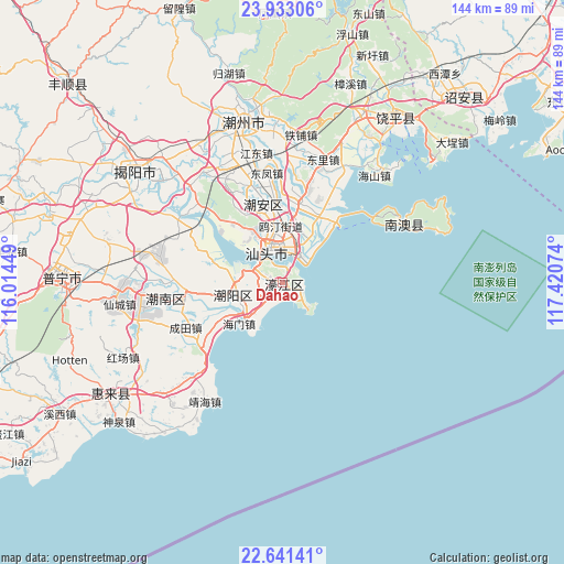
Dahao GPS coordinates[2]
23° 17' 19.68" North, 116° 43' 3.396" East
| Map corner | latitude | longitude |
|---|---|---|
| Upper-left | 23.93306°, | 116.01449° |
| Center: | 23.2888°, | 116.71761° |
| Lower-right: | 22.64141°, | 117.42074° |
| Map W x H: | 143.6×143.6 km | = 89.2×89.2mi |
| max Lat: | 53.31946° ⇑93.1% North |
| Dahao: | 23.2888° |
| min Lat: | ⇓6.9% South 18.22056° |
| min Long | Dahao | max Long |
| 75.07348° | 116.71761° | 134.28917° |
| W 64.5%⇐ | ⇒35.5% E |
Elevation
Elevation of Dahao is 49 m = 161 ft, and this is 435.8 m = 1430 ft below average elevation for this country.
| Max E: |
5622 m = 18445 ft | 70.8% |
| Avg. | 484.8 m = 1591 ft | |
| Dahao | 49 m = 161 ft | |
Min E: |
-3 m = -10 ft | 29.2% |
See also: China elevation on elevation.city.
Geographical zone
Dahao is located in North Torrid zone (between Equator and Tropic of Cancer). Distance of this Northern Tropic circle is 16.4 km =10.2 mi to North.| Distance of | km | miles | from Dahao |
|---|---|---|---|
| North Pole | 7417.6 | 4609.1 | to North |
| Arctic Circle | 4811.7 | 2989.9 | to North |
| Tropic Cancer | 16.4 | 10.2 | to North |
| Equator | 2589.5 | 1609 | to South |


Nearby cities:
15 places around Dahao: (largest is in red/bold)
• Banghai
5.4 km =3.4 mi,  219°
219°
• Chengnan
11.6 km =7.2 mi,  260°
260°
• Guang’ao
8.8 km =5.5 mi,  137°
137°
• Haimen
15.1 km =9.4 mi,  225°
225°
• Hepu
6.5 km =4 mi,  273°
273°
• Jinpu
17.9 km =11.1 mi, 255°
• Longxiang
13.6 km =8.5 mi,  1°
1°
• Majiao
2.3 km =1.4 mi,  204°
204°
• Outing
14.2 km =8.8 mi,  358°
358°
• Sanhe
6.3 km =3.9 mi, 268°
• Shantou
8.8 km =5.5 mi, 358°
• Tuopu
15.7 km =9.8 mi,  332°
332°
• Waisha
16.6 km =10.3 mi,  11°
11°
• Xinxi
13.7 km =8.5 mi,  22°
22°
• Yuxin
6 km =3.7 mi, 267°
Sources, notices
• [Note1] Compared only with cities in China existing in our database
• [Src1] Map data: © OpenStreetMap contributors (CC-BY-SA)
• [Src2] Other city data from geonames.org with taken over terms of usage.
• [Src3] Geographical zone / Annual Mean Temperature by Robert A. Rohde @ Wikipedia
