Shantou geodata
Shantou (Guangdong) is a seat of a second-order administrative division; located in China in Asia/Shanghai (GMT+8) time zone. With population of 5,329,024 people, there are 17 cities with bigger population in this country. Compared to other cities in China, 92.8% of cities are located further ↑North; 64.5% of cities are located further ←West and 84.3% of cities have higher elevation than Shantou. Note1


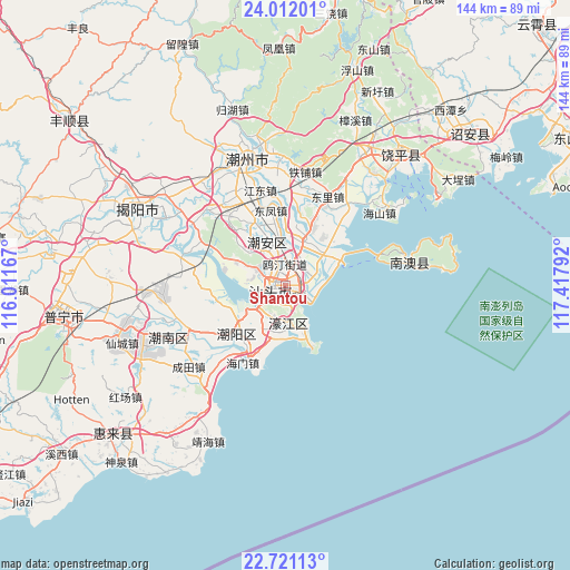
Shantou GPS coordinates[2]
23° 22' 5.304" North, 116° 42' 53.244" East
| Map corner | latitude | longitude |
|---|---|---|
| Upper-left | 24.01201°, | 116.01167° |
| Center: | 23.36814°, | 116.71479° |
| Lower-right: | 22.72113°, | 117.41792° |
| Map W x H: | 143.5×143.5 km | = 89.2×89.2mi |
| max Lat: | 53.31946° ⇑92.8% North |
| Shantou: | 23.36814° |
| min Lat: | ⇓7.2% South 18.22056° |
| min Long | Shantou | max Long |
| 75.07348° | 116.71479° | 134.28917° |
| W 64.5%⇐ | ⇒35.5% E |
Elevation
Elevation of Shantou is 17 m = 56 ft, and this is 467.8 m = 1535 ft below average elevation for this country.
| Max E: |
5622 m = 18445 ft | 84.3% |
| Avg. | 484.8 m = 1591 ft | |
| Shantou | 17 m = 56 ft | |
Min E: |
-3 m = -10 ft | 15.7% |
See also: Shantou elevation on elevation.city.
Geographical zone
Shantou is located in North Torrid zone (between Equator and Tropic of Cancer). Distance of this Northern Tropic circle is 7.6 km =4.7 mi to North.| Distance of | km | miles | from Shantou |
|---|---|---|---|
| North Pole | 7408.8 | 4603.6 | to North |
| Arctic Circle | 4802.9 | 2984.4 | to North |
| Tropic Cancer | 7.6 | 4.7 | to North |
| Equator | 2598.3 | 1614.5 | to South |


Nearby cities:
15 places around Shantou: (largest is in red/bold)
• Anbu
9.6 km =6 mi,  338°
338°
• Banghai
13.4 km =8.3 mi,  193°
193°
• Chenghua
11.8 km =7.3 mi,  28°
28°
• Dahao
8.8 km =5.5 mi,  178°
178°
• Guangyi
13 km =8.1 mi,  24°
24°
• Hepu
10.4 km =6.5 mi,  216°
216°
• Longxiang
4.8 km =3 mi,  7°
7°
• Majiao
11 km =6.8 mi, 183°
• Outing
5.3 km =3.3 mi,  358°
358°
• Sanhe
10.8 km =6.7 mi,  213°
213°
• Tuopu
8.7 km =5.4 mi,  305°
305°
• Tuotang
14.2 km =8.8 mi,  293°
293°
• Waisha
8.2 km =5.1 mi, 25°
• Xinxi
6.7 km =4.2 mi,  55°
55°
• Yuxin
10.8 km =6.7 mi, 212°
Sources, notices
• [Note1] Compared only with cities in China existing in our database
• [Src1] Map data: © OpenStreetMap contributors (CC-BY-SA)
• [Src2] Other city data from geonames.org with taken over terms of usage.
• [Src3] Geographical zone / Annual Mean Temperature by Robert A. Rohde @ Wikipedia
