Chengjiang geodata
Chengjiang (Jiangxi) is a seat of a third-order administrative division; located in China in Asia/Shanghai (GMT+8) time zone. In our database, there are 1268 cities with bigger population. Compared to other cities in China, 79.4% of cities are located further ↑North; 53.7% of cities are located further ←West and 68.4% of cities have higher elevation than Chengjiang. Note1


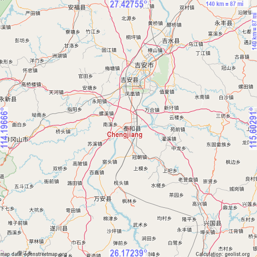
Chengjiang GPS coordinates[2]
26° 48' 6.156" North, 114° 53' 59.208" East
| Map corner | latitude | longitude |
|---|---|---|
| Upper-left | 27.42755°, | 114.19666° |
| Center: | 26.80171°, | 114.89978° |
| Lower-right: | 26.17239°, | 115.60291° |
| Map W x H: | 139.6×139.6 km | = 86.7×86.7mi |
| max Lat: | 53.31946° ⇑79.4% North |
| Chengjiang: | 26.80171° |
| min Lat: | ⇓20.6% South 18.22056° |
| min Long | Chengjiang | max Long |
| 75.07348° | 114.89978° | 134.28917° |
| W 53.7%⇐ | ⇒46.3% E |
Elevation
Elevation of Chengjiang is 58 m = 190 ft, and this is 426.8 m = 1400 ft below average elevation for this country.
| Max E: |
5622 m = 18445 ft | 68.4% |
| Avg. | 484.8 m = 1591 ft | |
| Chengjiang | 58 m = 190 ft | |
Min E: |
-3 m = -10 ft | 31.6% |
See also: China elevation on elevation.city.
Geographical zone
Chengjiang is located in North temperate zone (between Tropic of Cancer and the Arctic Circle). Distance of this Northern Tropic circle is 374.2 km =232.5 mi to South.| Distance of | km | miles | from Chengjiang |
|---|---|---|---|
| North Pole | 7027 | 4366.4 | to North |
| Arctic Circle | 4421.1 | 2747.1 | to North |
| Tropic Cancer | 374.2 | 232.5 | to South |
| Equator | 2980.1 | 1851.7 | to South |


Nearby cities:
15 places around Chengjiang: (largest is in red/bold)
• Antang
31 km =19.3 mi,  315°
315°
• Denglong
27.7 km =17.2 mi,  327°
327°
• Dunhou
27.6 km =17.1 mi,  0°
0°
• Futan
32.6 km =20.3 mi,  49°
49°
• Guanxi
22.7 km =14.1 mi,  103°
103°
• Hebu
34 km =21.1 mi,  11°
11°
• Qulai
28.9 km =18 mi,  352°
352°
• Shangyi
31.7 km =19.7 mi,  135°
135°
• Wanhe
16.4 km =10.2 mi, 50°
• Wenbei
26.4 km =16.4 mi, 53°
• Xinxu
26 km =16.2 mi,  63°
63°
• Yonghe
27.9 km =17.3 mi,  24°
24°
• Yuanqian
26.5 km =16.5 mi,  90°
90°
• Zhixia
29 km =18 mi, 46°
• Zhonglong
28.7 km =17.8 mi,  111°
111°
Sources, notices
• [Note1] Compared only with cities in China existing in our database
• [Src1] Map data: © OpenStreetMap contributors (CC-BY-SA)
• [Src2] Other city data from geonames.org with taken over terms of usage.
• [Src3] Geographical zone / Annual Mean Temperature by Robert A. Rohde @ Wikipedia
