Chencun geodata
Chencun (Guangdong) is a seat of a fourth-order administrative division; located in China in Asia/Shanghai (GMT+8) time zone. In our database, there are 1268 cities with bigger population. Compared to other cities in China, 94.6% of cities are located further ↑North; 56.2% of cities are located further →East and 95.9% of cities have higher elevation than Chencun. Note1


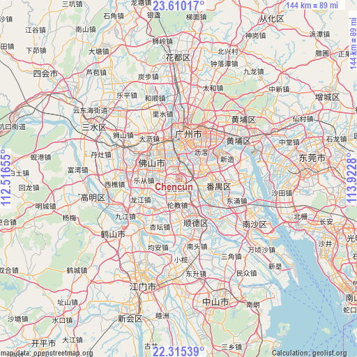
Chencun GPS coordinates[2]
22° 57' 51.588" North, 113° 13' 10.812" East
| Map corner | latitude | longitude |
|---|---|---|
| Upper-left | 23.61017°, | 112.51655° |
| Center: | 22.96433°, | 113.21967° |
| Lower-right: | 22.31539°, | 113.9228° |
| Map W x H: | 144×144 km | = 89.5×89.5mi |
| max Lat: | 53.31946° ⇑94.6% North |
| Chencun: | 22.96433° |
| min Lat: | ⇓5.4% South 18.22056° |
| min Long | Chencun | max Long |
| 75.07348° | 113.21967° | 134.28917° |
| W 43.8%⇐ | ⇒56.2% E |
Elevation
Elevation of Chencun is 6 m = 20 ft, and this is 478.8 m = 1571 ft below average elevation for this country.
| Max E: |
5622 m = 18445 ft | 95.9% |
| Avg. | 484.8 m = 1591 ft | |
| Chencun | 6 m = 20 ft | |
Min E: |
-3 m = -10 ft | 4.1% |
See also: China elevation on elevation.city.
Geographical zone
Chencun is located in North Torrid zone (between Equator and Tropic of Cancer). Distance of this Northern Tropic circle is 52.5 km =32.6 mi to North.| Distance of | km | miles | from Chencun |
|---|---|---|---|
| North Pole | 7453.7 | 4631.5 | to North |
| Arctic Circle | 4847.8 | 3012.3 | to North |
| Tropic Cancer | 52.5 | 32.6 | to North |
| Equator | 2553.4 | 1586.6 | to South |


Nearby cities:
15 places around Chencun: (largest is in red/bold)
• Beijiao
4.7 km =2.9 mi,  207°
207°
• Daliang
14.1 km =8.8 mi,  167°
167°
• Dashi
10.8 km =6.7 mi,  53°
53°
• Dongjiao
13.1 km =8.1 mi,  359°
359°
• Dongsha
11.9 km =7.4 mi,  14°
14°
• Foshan
11.4 km =7.1 mi,  307°
307°
• Guicheng
8.7 km =5.4 mi,  336°
336°
• Lunjiao
10.1 km =6.3 mi,  184°
184°
• Luopu
11.4 km =7.1 mi,  39°
39°
• Shatou
12 km =7.5 mi,  94°
94°
• Shawan
13 km =8.1 mi,  117°
117°
• Shibi
5.9 km =3.7 mi,  75°
75°
• Shiqiao
14.3 km =8.9 mi,  98°
98°
• Zhongcun
9.6 km =6 mi, 82°
• Zumiao
11.4 km =7.1 mi, 306°
Sources, notices
• [Note1] Compared only with cities in China existing in our database
• [Src1] Map data: © OpenStreetMap contributors (CC-BY-SA)
• [Src2] Other city data from geonames.org with taken over terms of usage.
• [Src3] Geographical zone / Annual Mean Temperature by Robert A. Rohde @ Wikipedia
