Zumiao geodata
Zumiao (Guangdong) is a seat of a fourth-order administrative division; located in China in Asia/Shanghai (GMT+8) time zone. In our database, there are 1268 cities with bigger population. Compared to other cities in China, 94.4% of cities are located further ↑North; 56.8% of cities are located further →East and 99.7% of cities have higher elevation than Zumiao. Note1


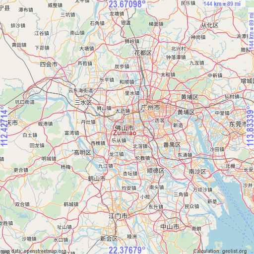
Zumiao GPS coordinates[2]
23° 1' 31.584" North, 113° 7' 48.936" East
| Map corner | latitude | longitude |
|---|---|---|
| Upper-left | 23.67098°, | 112.42714° |
| Center: | 23.02544°, | 113.13026° |
| Lower-right: | 22.37679°, | 113.83339° |
| Map W x H: | 143.9×143.9 km | = 89.4×89.4mi |
| max Lat: | 53.31946° ⇑94.4% North |
| Zumiao: | 23.02544° |
| min Lat: | ⇓5.6% South 18.22056° |
| min Long | Zumiao | max Long |
| 75.07348° | 113.13026° | 134.28917° |
| W 43.2%⇐ | ⇒56.8% E |
Elevation
Elevation of Zumiao is 1 m = 3 ft, and this is 483.8 m = 1587 ft below average elevation for this country.
| Max E: |
5622 m = 18445 ft | 99.7% |
| Avg. | 484.8 m = 1591 ft | |
| Zumiao | 1 m = 3 ft | |
Min E: |
-3 m = -10 ft | 0.3% |
See also: China elevation on elevation.city.
Geographical zone
Zumiao is located in North Torrid zone (between Equator and Tropic of Cancer). Distance of this Northern Tropic circle is 45.7 km =28.4 mi to North.| Distance of | km | miles | from Zumiao |
|---|---|---|---|
| North Pole | 7446.9 | 4627.3 | to North |
| Arctic Circle | 4841 | 3008.1 | to North |
| Tropic Cancer | 45.7 | 28.4 | to North |
| Equator | 2560.2 | 1590.8 | to South |


Nearby cities:
15 places around Zumiao: (largest is in red/bold)
• Beijiao
13 km =8.1 mi,  147°
147°
• Chencun
11.4 km =7.1 mi,  126°
126°
• Dali
10.6 km =6.6 mi,  352°
352°
• Dongjiao
11 km =6.8 mi,  55°
55°
• Dongsha
13.1 km =8.1 mi,  69°
69°
• Foshan
0.2 km =0.1 mi,  40°
40°
• Guangzhou
15.9 km =9.9 mi,  50°
50°
• Guicheng
5.8 km =3.6 mi,  78°
78°
• Huadi
12.4 km =7.7 mi, 49°
• Lecong
9.3 km =5.8 mi,  216°
216°
• Luocun
10.5 km =6.5 mi,  289°
289°
• Nanzhuang
13.7 km =8.5 mi,  252°
252°
• Shibi
15.8 km =9.8 mi,  109°
109°
• Shiwan
6.1 km =3.8 mi,  243°
243°
• Zhangcha
5.7 km =3.5 mi,  283°
283°
Sources, notices
• [Note1] Compared only with cities in China existing in our database
• [Src1] Map data: © OpenStreetMap contributors (CC-BY-SA)
• [Src2] Other city data from geonames.org with taken over terms of usage.
• [Src3] Geographical zone / Annual Mean Temperature by Robert A. Rohde @ Wikipedia
