Changhe geodata
Changhe (Zhejiang) is a seat of a fourth-order administrative division; located in China in Asia/Shanghai (GMT+8) time zone. In our database, there are 1268 cities with bigger population. Compared to other cities in China, 51.9% of cities are located further ↑North; 88.5% of cities are located further ←West and 94.3% of cities have higher elevation than Changhe. Note1


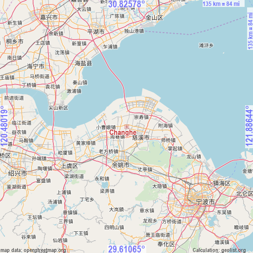
Changhe GPS coordinates[2]
30° 13' 12.324" North, 121° 10' 59.916" East
| Map corner | latitude | longitude |
|---|---|---|
| Upper-left | 30.82578°, | 120.48019° |
| Center: | 30.22009°, | 121.18331° |
| Lower-right: | 29.61065°, | 121.88644° |
| Map W x H: | 135.1×135.1 km | = 83.9×83.9mi |
| max Lat: | 53.31946° ⇑51.9% North |
| Changhe: | 30.22009° |
| min Lat: | ⇓48.1% South 18.22056° |
| min Long | Changhe | max Long |
| 75.07348° | 121.18331° | 134.28917° |
| W 88.5%⇐ | ⇒11.5% E |
Elevation
Elevation of Changhe is 7 m = 23 ft, and this is 477.8 m = 1568 ft below average elevation for this country.
| Max E: |
5622 m = 18445 ft | 94.3% |
| Avg. | 484.8 m = 1591 ft | |
| Changhe | 7 m = 23 ft | |
Min E: |
-3 m = -10 ft | 5.7% |
See also: China elevation on elevation.city.
Geographical zone
Changhe is located in North temperate zone (between Tropic of Cancer and the Arctic Circle). Distance of this Northern Tropic circle is 754.2 km =468.6 mi to South.| Distance of | km | miles | from Changhe |
|---|---|---|---|
| North Pole | 6646.9 | 4130.2 | to North |
| Arctic Circle | 4041 | 2511 | to North |
| Tropic Cancer | 754.2 | 468.6 | to South |
| Equator | 3360.2 | 2087.9 | to South |


Nearby cities:
15 places around Changhe: (largest is in red/bold)
• Andong
6.2 km =3.9 mi,  30°
30°
• Henghe
11.3 km =7 mi,  152°
152°
• Kandun
7.3 km =4.5 mi,  85°
85°
• Kuangyan
13.3 km =8.3 mi,  125°
125°
• Langxia
11.9 km =7.4 mi,  240°
240°
• Liutangting
10 km =6.2 mi,  51°
51°
• Shengshan
13.5 km =8.4 mi,  83°
83°
• Simen
15.3 km =9.5 mi, 244°
• Tianyuan
2.3 km =1.4 mi,  184°
184°
• Xiaolin
12.9 km =8 mi,  114°
114°
• Xinpu
17.6 km =10.9 mi, 81°
• Xushan
7.7 km =4.8 mi, 129°
• Yangjialusanqiu
11.1 km =6.9 mi,  269°
269°
• Zhouxiang
7.4 km =4.6 mi,  226°
226°
• Zonghan
5.1 km =3.2 mi, 127°
Sources, notices
• [Note1] Compared only with cities in China existing in our database
• [Src1] Map data: © OpenStreetMap contributors (CC-BY-SA)
• [Src2] Other city data from geonames.org with taken over terms of usage.
• [Src3] Geographical zone / Annual Mean Temperature by Robert A. Rohde @ Wikipedia
