Langxia geodata
Langxia (Zhejiang) is a seat of a third-order administrative division; located in China in Asia/Shanghai (GMT+8) time zone. In our database, there are 1268 cities with bigger population. Compared to other cities in China, 52.4% of cities are located further ↑North; 88.1% of cities are located further ←West and 94.3% of cities have higher elevation than Langxia. Note1


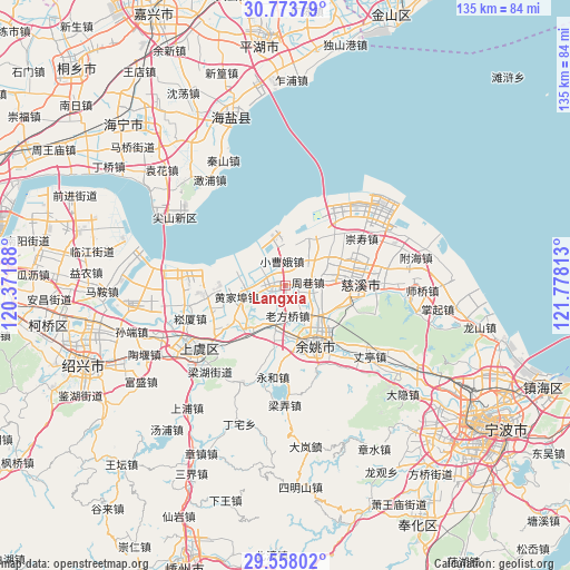
Langxia GPS coordinates[2]
30° 10' 4.008" North, 121° 4' 30" East
| Map corner | latitude | longitude |
|---|---|---|
| Upper-left | 30.77379°, | 120.37188° |
| Center: | 30.16778°, | 121.075° |
| Lower-right: | 29.55802°, | 121.77813° |
| Map W x H: | 135.2×135.2 km | = 84×84mi |
| max Lat: | 53.31946° ⇑52.4% North |
| Langxia: | 30.16778° |
| min Lat: | ⇓47.6% South 18.22056° |
| min Long | Langxia | max Long |
| 75.07348° | 121.075° | 134.28917° |
| W 88.1%⇐ | ⇒11.9% E |
Elevation
Elevation of Langxia is 7 m = 23 ft, and this is 477.8 m = 1568 ft below average elevation for this country.
| Max E: |
5622 m = 18445 ft | 94.3% |
| Avg. | 484.8 m = 1591 ft | |
| Langxia | 7 m = 23 ft | |
Min E: |
-3 m = -10 ft | 5.7% |
See also: China elevation on elevation.city.
Geographical zone
Langxia is located in North temperate zone (between Tropic of Cancer and the Arctic Circle). Distance of this Northern Tropic circle is 748.4 km =465 mi to South.| Distance of | km | miles | from Langxia |
|---|---|---|---|
| North Pole | 6652.7 | 4133.8 | to North |
| Arctic Circle | 4046.8 | 2514.6 | to North |
| Tropic Cancer | 748.4 | 465 | to South |
| Equator | 3354.3 | 2084.3 | to South |


Nearby cities:
15 places around Langxia: (largest is in red/bold)
• Andong
17.5 km =10.9 mi,  50°
50°
• Changhe
11.9 km =7.4 mi,  60°
60°
• Henghe
16.2 km =10.1 mi,  105°
105°
• Huangjiabu
11.8 km =7.3 mi,  256°
256°
• Linshan
8.1 km =5 mi, 259°
• Mazhu
10.3 km =6.4 mi,  195°
195°
• Moushan
13.1 km =8.1 mi,  218°
218°
• Simen
3.5 km =2.2 mi, 258°
• Tianyuan
10.8 km =6.7 mi,  70°
70°
• Xiaodong
15.1 km =9.4 mi,  170°
170°
• Xushan
16.4 km =10.2 mi,  86°
86°
• Yangjialusanqiu
5.8 km =3.6 mi,  353°
353°
• Yuyao
14.9 km =9.3 mi,  151°
151°
• Zhouxiang
5.1 km =3.2 mi,  81°
81°
• Zonghan
14.7 km =9.1 mi, 79°
Sources, notices
• [Note1] Compared only with cities in China existing in our database
• [Src1] Map data: © OpenStreetMap contributors (CC-BY-SA)
• [Src2] Other city data from geonames.org with taken over terms of usage.
• [Src3] Geographical zone / Annual Mean Temperature by Robert A. Rohde @ Wikipedia
