Buhe geodata
Buhe (Hubei) is a seat of a fourth-order administrative division; located in China in Asia/Shanghai (GMT+8) time zone. With population of 106,347 people, there are 412 cities with bigger population in this country. Compared to other cities in China, 51.3% of cities are located further ↑North; 61.5% of cities are located further →East and 74.1% of cities have higher elevation than Buhe. Note1


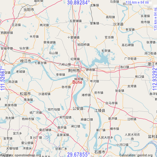
Buhe GPS coordinates[2]
30° 17' 15.252" North, 112° 13' 47.244" East
| Map corner | latitude | longitude |
|---|---|---|
| Upper-left | 30.89284°, | 111.52667° |
| Center: | 30.28757°, | 112.22979° |
| Lower-right: | 29.67855°, | 112.93292° |
| Map W x H: | 135×135 km | = 83.9×83.9mi |
| max Lat: | 53.31946° ⇑51.3% North |
| Buhe: | 30.28757° |
| min Lat: | ⇓48.7% South 18.22056° |
| min Long | Buhe | max Long |
| 75.07348° | 112.22979° | 134.28917° |
| W 38.5%⇐ | ⇒61.5% E |
Elevation
Elevation of Buhe is 39 m = 128 ft, and this is 445.8 m = 1463 ft below average elevation for this country.
| Max E: |
5622 m = 18445 ft | 74.1% |
| Avg. | 484.8 m = 1591 ft | |
| Buhe | 39 m = 128 ft | |
Min E: |
-3 m = -10 ft | 25.9% |
See also: Buhe elevation on elevation.city.
Geographical zone
Buhe is located in North temperate zone (between Tropic of Cancer and the Arctic Circle). Distance of this Northern Tropic circle is 761.7 km =473.3 mi to South.| Distance of | km | miles | from Buhe |
|---|---|---|---|
| North Pole | 6639.4 | 4125.5 | to North |
| Arctic Circle | 4033.5 | 2506.3 | to North |
| Tropic Cancer | 761.7 | 473.3 | to South |
| Equator | 3367.7 | 2092.6 | to South |


Nearby cities:
15 places around Buhe: (largest is in red/bold)
• Cenhe
13.6 km =8.5 mi,  97°
97°
• Chengnan
8.5 km =5.3 mi,  322°
322°
• Dongcheng
8.1 km =5 mi,  330°
330°
• Douhudi
25.2 km =15.7 mi,  181°
181°
• Jinan
18 km =11.2 mi,  350°
350°
• Jingzhou
7.9 km =4.9 mi, 331°
• Libu
16.1 km =10 mi,  283°
283°
• Luochang
12.9 km =8 mi,  51°
51°
• Mishi
12.6 km =7.8 mi,  238°
238°
• Shashi
2.6 km =1.6 mi,  33°
33°
• Tanqiao
15.1 km =9.4 mi,  155°
155°
• Xicheng
9.3 km =5.8 mi, 329°
• Yangjiachang
25.2 km =15.7 mi,  167°
167°
• Yingcheng
9.5 km =5.9 mi,  342°
342°
• Zishi
20.8 km =12.9 mi,  124°
124°
Sources, notices
• [Note1] Compared only with cities in China existing in our database
• [Src1] Map data: © OpenStreetMap contributors (CC-BY-SA)
• [Src2] Other city data from geonames.org with taken over terms of usage.
• [Src3] Geographical zone / Annual Mean Temperature by Robert A. Rohde @ Wikipedia
