Bangtou geodata
Bangtou (Fujian) is a seat of a fourth-order administrative division; located in China in Asia/Shanghai (GMT+8) time zone. In our database, there are 1268 cities with bigger population. Compared to other cities in China, 84.6% of cities are located further ↑North; 74.7% of cities are located further ←West and 68.9% of cities have higher elevation than Bangtou. Note1


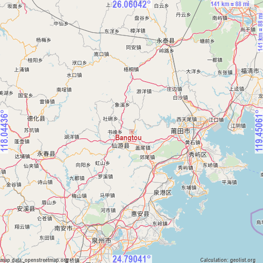
Bangtou GPS coordinates[2]
25° 25' 37.524" North, 118° 44' 50.928" East
| Map corner | latitude | longitude |
|---|---|---|
| Upper-left | 26.06042°, | 118.04436° |
| Center: | 25.42709°, | 118.74748° |
| Lower-right: | 24.79041°, | 119.45061° |
| Map W x H: | 141.2×141.2 km | = 87.7×87.7mi |
| max Lat: | 53.31946° ⇑84.6% North |
| Bangtou: | 25.42709° |
| min Lat: | ⇓15.4% South 18.22056° |
| min Long | Bangtou | max Long |
| 75.07348° | 118.74748° | 134.28917° |
| W 74.7%⇐ | ⇒25.3% E |
Elevation
Elevation of Bangtou is 56 m = 184 ft, and this is 428.8 m = 1407 ft below average elevation for this country.
| Max E: |
5622 m = 18445 ft | 68.9% |
| Avg. | 484.8 m = 1591 ft | |
| Bangtou | 56 m = 184 ft | |
Min E: |
-3 m = -10 ft | 31.1% |
See also: China elevation on elevation.city.
Geographical zone
Bangtou is located in North temperate zone (between Tropic of Cancer and the Arctic Circle). Distance of this Northern Tropic circle is 221.3 km =137.5 mi to South.| Distance of | km | miles | from Bangtou |
|---|---|---|---|
| North Pole | 7179.8 | 4461.3 | to North |
| Arctic Circle | 4573.9 | 2842.1 | to North |
| Tropic Cancer | 221.3 | 137.5 | to South |
| Equator | 2827.2 | 1756.7 | to South |


Nearby cities:
15 places around Bangtou: (largest is in red/bold)
• Changtai
20.1 km =12.5 mi,  66°
66°
• Chengdong
8 km =5 mi,  215°
215°
• Daji
12.9 km =8 mi,  241°
241°
• Duwei
17.2 km =10.7 mi,  266°
266°
• Gaiwei
10.3 km =6.4 mi,  144°
144°
• Huating
15 km =9.3 mi,  109°
109°
• Jiaowei
15.8 km =9.8 mi,  148°
148°
• Laidian
10.6 km =6.6 mi,  193°
193°
• Longhua
13.3 km =8.3 mi,  226°
226°
• Shexing
14.1 km =8.8 mi,  301°
301°
• Shicang
19.5 km =12.1 mi,  1°
1°
• Shufeng
9.1 km =5.7 mi, 270°
• Xiangxi
15.6 km =9.7 mi,  340°
340°
• Xiyuan
19.9 km =12.4 mi,  292°
292°
• Zhongshan
12.4 km =7.7 mi,  20°
20°
Sources, notices
• [Note1] Compared only with cities in China existing in our database
• [Src1] Map data: © OpenStreetMap contributors (CC-BY-SA)
• [Src2] Other city data from geonames.org with taken over terms of usage.
• [Src3] Geographical zone / Annual Mean Temperature by Robert A. Rohde @ Wikipedia
