Duwei geodata
Duwei (Fujian) is a seat of a fourth-order administrative division; located in China in Asia/Shanghai (GMT+8) time zone. In our database, there are 1268 cities with bigger population. Compared to other cities in China, 84.6% of cities are located further ↑North; 73.7% of cities are located further ←West and 56.6% of cities have higher elevation than Duwei. Note1


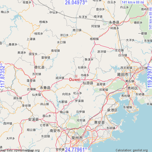
Duwei GPS coordinates[2]
25° 24' 58.824" North, 118° 34' 35.904" East
| Map corner | latitude | longitude |
|---|---|---|
| Upper-left | 26.04973°, | 117.87352° |
| Center: | 25.41634°, | 118.57664° |
| Lower-right: | 24.77961°, | 119.27977° |
| Map W x H: | 141.2×141.2 km | = 87.7×87.7mi |
| max Lat: | 53.31946° ⇑84.6% North |
| Duwei: | 25.41634° |
| min Lat: | ⇓15.4% South 18.22056° |
| min Long | Duwei | max Long |
| 75.07348° | 118.57664° | 134.28917° |
| W 73.7%⇐ | ⇒26.3% E |
Elevation
Elevation of Duwei is 120 m = 394 ft, and this is 364.8 m = 1197 ft below average elevation for this country.
| Max E: |
5622 m = 18445 ft | 56.6% |
| Avg. | 484.8 m = 1591 ft | |
| Duwei | 120 m = 394 ft | |
Min E: |
-3 m = -10 ft | 43.4% |
See also: China elevation on elevation.city.
Geographical zone
Duwei is located in North temperate zone (between Tropic of Cancer and the Arctic Circle). Distance of this Northern Tropic circle is 220.1 km =136.8 mi to South.| Distance of | km | miles | from Duwei |
|---|---|---|---|
| North Pole | 7181 | 4462.1 | to North |
| Arctic Circle | 4575.1 | 2842.8 | to North |
| Tropic Cancer | 220.1 | 136.8 | to South |
| Equator | 2826 | 1756 | to South |


Nearby cities:
15 places around Duwei: (largest is in red/bold)
• Bangtou
17.2 km =10.7 mi,  86°
86°
• Chengdong
13.6 km =8.5 mi,  113°
113°
• Daji
7.6 km =4.7 mi,  129°
129°
• Fengshan
17.8 km =11.1 mi,  353°
353°
• Gaiwei
24.2 km =15 mi, 107°
• Hongshan
15.4 km =9.6 mi,  174°
174°
• Huyang
15.5 km =9.6 mi,  265°
265°
• Laidian
17.2 km =10.7 mi,  121°
121°
• Longhua
10.9 km =6.8 mi,  136°
136°
• Shexing
9.9 km =6.2 mi,  30°
30°
• Shufeng
8.2 km =5.1 mi,  81°
81°
• Waishan
14.9 km =9.3 mi,  224°
224°
• Xiangxi
20 km =12.4 mi,  37°
37°
• Xiyuan
9 km =5.6 mi, 352°
• Zhongshan
25 km =15.5 mi,  59°
59°
Sources, notices
• [Note1] Compared only with cities in China existing in our database
• [Src1] Map data: © OpenStreetMap contributors (CC-BY-SA)
• [Src2] Other city data from geonames.org with taken over terms of usage.
• [Src3] Geographical zone / Annual Mean Temperature by Robert A. Rohde @ Wikipedia
