Baita geodata
Baita (Zhejiang) is a seat of a fourth-order administrative division; located in China in Asia/Shanghai (GMT+8) time zone. In our database, there are 1268 cities with bigger population. Compared to other cities in China, 67.4% of cities are located further ↑North; 85.6% of cities are located further ←West and 60.8% of cities have higher elevation than Baita. Note1


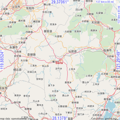
Baita GPS coordinates[2]
28° 45' 21.672" North, 120° 35' 18.096" East
| Map corner | latitude | longitude |
|---|---|---|
| Upper-left | 29.37061°, | 119.88524° |
| Center: | 28.75602°, | 120.58836° |
| Lower-right: | 28.1378°, | 121.29149° |
| Map W x H: | 137.1×137.1 km | = 85.2×85.2mi |
| max Lat: | 53.31946° ⇑67.4% North |
| Baita: | 28.75602° |
| min Lat: | ⇓32.6% South 18.22056° |
| min Long | Baita | max Long |
| 75.07348° | 120.58836° | 134.28917° |
| W 85.6%⇐ | ⇒14.4% E |
Elevation
Elevation of Baita is 94 m = 308 ft, and this is 390.8 m = 1282 ft below average elevation for this country.
| Max E: |
5622 m = 18445 ft | 60.8% |
| Avg. | 484.8 m = 1591 ft | |
| Baita | 94 m = 308 ft | |
Min E: |
-3 m = -10 ft | 39.2% |
See also: China elevation on elevation.city.
Geographical zone
Baita is located in North temperate zone (between Tropic of Cancer and the Arctic Circle). Distance of this Northern Tropic circle is 591.5 km =367.5 mi to South.| Distance of | km | miles | from Baita |
|---|---|---|---|
| North Pole | 6809.7 | 4231.4 | to North |
| Arctic Circle | 4203.8 | 2612.1 | to North |
| Tropic Cancer | 591.5 | 367.5 | to South |
| Equator | 3197.4 | 1986.8 | to South |


Nearby cities:
15 places around Baita: (largest is in red/bold)
• Anzhou
18.4 km =11.4 mi,  42°
42°
• Bulu
13 km =8.1 mi,  67°
67°
• Butou
6.7 km =4.2 mi,  267°
267°
• Danzhu
9.4 km =5.8 mi,  190°
190°
• Fuying
17.4 km =10.8 mi,  47°
47°
• Gao’er
18.6 km =11.6 mi,  357°
357°
• Guanlu
11 km =6.8 mi, 38°
• Hengxi
11.6 km =7.2 mi,  258°
258°
• Nanfeng
18.4 km =11.4 mi, 51°
• Potan
5.3 km =3.3 mi,  254°
254°
• Qiushan
18 km =11.2 mi, 249°
• Shangzhang
16.7 km =10.4 mi,  126°
126°
• Tianshi
5 km =3.1 mi,  55°
55°
• Weixin
19.8 km =12.3 mi,  7°
7°
• Xianju
17.8 km =11.1 mi, 51°
Sources, notices
• [Note1] Compared only with cities in China existing in our database
• [Src1] Map data: © OpenStreetMap contributors (CC-BY-SA)
• [Src2] Other city data from geonames.org with taken over terms of usage.
• [Src3] Geographical zone / Annual Mean Temperature by Robert A. Rohde @ Wikipedia
