Shangzhang geodata
Shangzhang (Zhejiang) is a seat of a fourth-order administrative division; located in China in Asia/Shanghai (GMT+8) time zone. In our database, there are 1268 cities with bigger population. Compared to other cities in China, 68.3% of cities are located further ↑North; 86.4% of cities are located further ←West and 65.8% of cities have lower elevation than Shangzhang. Note1


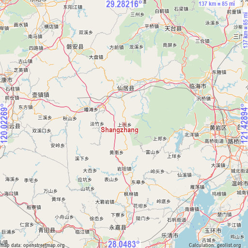
Shangzhang GPS coordinates[2]
28° 40' 1.38" North, 120° 43' 32.916" East
| Map corner | latitude | longitude |
|---|---|---|
| Upper-left | 29.28216°, | 120.02269° |
| Center: | 28.66705°, | 120.72581° |
| Lower-right: | 28.0483°, | 121.42894° |
| Map W x H: | 137.2×137.2 km | = 85.3×85.3mi |
| max Lat: | 53.31946° ⇑68.3% North |
| Shangzhang: | 28.66705° |
| min Lat: | ⇓31.7% South 18.22056° |
| min Long | Shangzhang | max Long |
| 75.07348° | 120.72581° | 134.28917° |
| W 86.4%⇐ | ⇒13.6% E |
Elevation
Elevation of Shangzhang is 340 m = 1115 ft, and this is 144.8 m = 475 ft below average elevation for this country.
| Max E: |
5622 m = 18445 ft | 34.2% |
| Avg. | 484.8 m = 1591 ft | |
| Shangzhang | 340 m = 1115 ft | |
Min E: |
-3 m = -10 ft | 65.8% |
See also: China elevation on elevation.city.
Geographical zone
Shangzhang is located in North temperate zone (between Tropic of Cancer and the Arctic Circle). Distance of this Northern Tropic circle is 581.6 km =361.4 mi to South.| Distance of | km | miles | from Shangzhang |
|---|---|---|---|
| North Pole | 6819.6 | 4237.5 | to North |
| Arctic Circle | 4213.7 | 2618.3 | to North |
| Tropic Cancer | 581.6 | 361.4 | to South |
| Equator | 3187.5 | 1980.6 | to South |


Nearby cities:
15 places around Shangzhang: (largest is in red/bold)
• Baita
16.7 km =10.4 mi,  306°
306°
• Bulu
14.9 km =9.3 mi,  354°
354°
• Danzhu
15.1 km =9.4 mi,  272°
272°
• Dazhan
19.2 km =11.9 mi,  26°
26°
• Fushan
21.7 km =13.5 mi,  134°
134°
• Guanlu
19.6 km =12.2 mi,  340°
340°
• Huangnan
15.9 km =9.9 mi,  195°
195°
• Nanfeng
21.3 km =13.2 mi,  2°
2°
• Potan
20.4 km =12.7 mi,  294°
294°
• Shangzheng
20.8 km =12.9 mi,  111°
111°
• Shuangmiao
18.5 km =11.5 mi,  39°
39°
• Tianshi
15.7 km =9.8 mi,  324°
324°
• Xianju
20.9 km =13 mi, 1°
• Zhangxi
21.1 km =13.1 mi,  166°
166°
• Zhuxi
12.4 km =7.7 mi,  58°
58°
Sources, notices
• [Note1] Compared only with cities in China existing in our database
• [Src1] Map data: © OpenStreetMap contributors (CC-BY-SA)
• [Src2] Other city data from geonames.org with taken over terms of usage.
• [Src3] Geographical zone / Annual Mean Temperature by Robert A. Rohde @ Wikipedia
