Bachuan geodata
Bachuan (Chongqing) is a seat of a third-order administrative division; located in China in Asia/Shanghai (GMT+8) time zone. In our database, there are 1268 cities with bigger population. Compared to other cities in China, 55.8% of cities are located further ↑North; 86.7% of cities are located further →East and 61.7% of cities have lower elevation than Bachuan. Note1


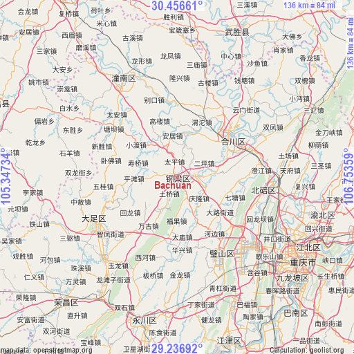
Bachuan GPS coordinates[2]
29° 50' 55.068" North, 106° 3' 1.656" East
| Map corner | latitude | longitude |
|---|---|---|
| Upper-left | 30.45661°, | 105.34734° |
| Center: | 29.84863°, | 106.05046° |
| Lower-right: | 29.23692°, | 106.75359° |
| Map W x H: | 135.6×135.6 km | = 84.3×84.3mi |
| max Lat: | 53.31946° ⇑55.8% North |
| Bachuan: | 29.84863° |
| min Lat: | ⇓44.2% South 18.22056° |
| min Long | Bachuan | max Long |
| 75.07348° | 106.05046° | 134.28917° |
| W 13.3%⇐ | ⇒86.7% E |
Elevation
Elevation of Bachuan is 279 m = 915 ft, and this is 205.8 m = 675 ft below average elevation for this country.
| Max E: |
5622 m = 18445 ft | 38.3% |
| Avg. | 484.8 m = 1591 ft | |
| Bachuan | 279 m = 915 ft | |
Min E: |
-3 m = -10 ft | 61.7% |
See also: China elevation on elevation.city.
Geographical zone
Bachuan is located in North temperate zone (between Tropic of Cancer and the Arctic Circle). Distance of this Northern Tropic circle is 712.9 km =443 mi to South.| Distance of | km | miles | from Bachuan |
|---|---|---|---|
| North Pole | 6688.2 | 4155.9 | to North |
| Arctic Circle | 4082.3 | 2536.6 | to North |
| Tropic Cancer | 712.9 | 443 | to South |
| Equator | 3318.9 | 2062.3 | to South |


Nearby cities:
15 places around Bachuan: (largest is in red/bold)
• Baiyang
12.9 km =8 mi,  13°
13°
• Dongcheng
2.2 km =1.4 mi,  92°
92°
• Erping
11.7 km =7.3 mi,  61°
61°
• Guoliang
15.4 km =9.6 mi,  233°
233°
• Hufeng
15.9 km =9.9 mi,  158°
158°
• Jiuxian
14.8 km =9.2 mi,  84°
84°
• Lüfeng
7.5 km =4.7 mi,  278°
278°
• Nancheng
1.5 km =0.9 mi,  175°
175°
• Pulü
11 km =6.8 mi,  108°
108°
• Qinglong
11.5 km =7.1 mi,  133°
133°
• Shiyu
9.5 km =5.9 mi,  154°
154°
• Shuikou
10.9 km =6.8 mi,  33°
33°
• Taiping
6.2 km =3.9 mi,  349°
349°
• Tuqiao
9.5 km =5.9 mi,  202°
202°
• Yongxi
14 km =8.7 mi,  209°
209°
Sources, notices
• [Note1] Compared only with cities in China existing in our database
• [Src1] Map data: © OpenStreetMap contributors (CC-BY-SA)
• [Src2] Other city data from geonames.org with taken over terms of usage.
• [Src3] Geographical zone / Annual Mean Temperature by Robert A. Rohde @ Wikipedia
