Dajiahe geodata
Dajiahe (Zhejiang) is a seat of a fourth-order administrative division; located in China in Asia/Shanghai (GMT+8) time zone. In our database, there are 1268 cities with bigger population. Compared to other cities in China, 60.5% of cities are located further ↑North; 90.2% of cities are located further ←West and 88.7% of cities have higher elevation than Dajiahe. Note1


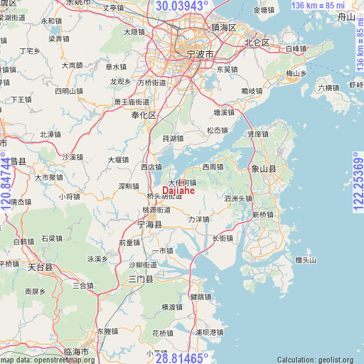
Dajiahe GPS coordinates[2]
29° 25' 44.004" North, 121° 33' 2.016" East
| Map corner | latitude | longitude |
|---|---|---|
| Upper-left | 30.03943°, | 120.84744° |
| Center: | 29.42889°, | 121.55056° |
| Lower-right: | 28.81465°, | 122.25369° |
| Map W x H: | 136.2×136.2 km | = 84.6×84.6mi |
| max Lat: | 53.31946° ⇑60.5% North |
| Dajiahe: | 29.42889° |
| min Lat: | ⇓39.5% South 18.22056° |
| min Long | Dajiahe | max Long |
| 75.07348° | 121.55056° | 134.28917° |
| W 90.2%⇐ | ⇒9.8% E |
Elevation
Elevation of Dajiahe is 11 m = 36 ft, and this is 473.8 m = 1554 ft below average elevation for this country.
| Max E: |
5622 m = 18445 ft | 88.7% |
| Avg. | 484.8 m = 1591 ft | |
| Dajiahe | 11 m = 36 ft | |
Min E: |
-3 m = -10 ft | 11.3% |
See also: China elevation on elevation.city.
Geographical zone
Dajiahe is located in North temperate zone (between Tropic of Cancer and the Arctic Circle). Distance of this Northern Tropic circle is 666.3 km =414 mi to South.| Distance of | km | miles | from Dajiahe |
|---|---|---|---|
| North Pole | 6734.9 | 4184.9 | to North |
| Arctic Circle | 4129 | 2565.6 | to North |
| Tropic Cancer | 666.3 | 414 | to South |
| Equator | 3272.2 | 2033.3 | to South |


Nearby cities:
15 places around Dajiahe: (largest is in red/bold)
• Changjie
24.9 km =15.5 mi,  143°
143°
• Chengguan
19.5 km =12.1 mi,  216°
216°
• Chunhu
17 km =10.6 mi,  348°
348°
• Huangtan
23.8 km =14.8 mi,  231°
231°
• Liyang
15 km =9.3 mi,  155°
155°
• Ninghai
19.8 km =12.3 mi, 218°
• Qiangtou
22.6 km =14 mi,  80°
80°
• Qiucun
20.7 km =12.9 mi,  19°
19°
• Shangtian
25.3 km =15.7 mi,  326°
326°
• Shenzhen
20.5 km =12.7 mi,  265°
265°
• Sizhoutou
21.9 km =13.6 mi,  106°
106°
• Song’ao
24.2 km =15 mi,  32°
32°
• Xiashan
4.4 km =2.7 mi, 334°
• Xidian
13.3 km =8.3 mi,  301°
301°
• Xizhou
13.1 km =8.1 mi,  64°
64°
Sources, notices
• [Note1] Compared only with cities in China existing in our database
• [Src1] Map data: © OpenStreetMap contributors (CC-BY-SA)
• [Src2] Other city data from geonames.org with taken over terms of usage.
• [Src3] Geographical zone / Annual Mean Temperature by Robert A. Rohde @ Wikipedia
