Shangtian geodata
Shangtian (Zhejiang) is a seat of a fourth-order administrative division; located in China in Asia/Shanghai (GMT+8) time zone. In our database, there are 1268 cities with bigger population. Compared to other cities in China, 58.4% of cities are located further ↑North; 89.6% of cities are located further ←West and 81.6% of cities have higher elevation than Shangtian. Note1


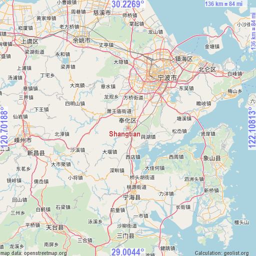
Shangtian GPS coordinates[2]
29° 37' 3" North, 121° 24' 18" East
| Map corner | latitude | longitude |
|---|---|---|
| Upper-left | 30.2269°, | 120.70188° |
| Center: | 29.6175°, | 121.405° |
| Lower-right: | 29.0044°, | 122.10813° |
| Map W x H: | 135.9×135.9 km | = 84.4×84.4mi |
| max Lat: | 53.31946° ⇑58.4% North |
| Shangtian: | 29.6175° |
| min Lat: | ⇓41.6% South 18.22056° |
| min Long | Shangtian | max Long |
| 75.07348° | 121.405° | 134.28917° |
| W 89.6%⇐ | ⇒10.4% E |
Elevation
Elevation of Shangtian is 23 m = 75 ft, and this is 461.8 m = 1515 ft below average elevation for this country.
| Max E: |
5622 m = 18445 ft | 81.6% |
| Avg. | 484.8 m = 1591 ft | |
| Shangtian | 23 m = 75 ft | |
Min E: |
-3 m = -10 ft | 18.4% |
See also: China elevation on elevation.city.
Geographical zone
Shangtian is located in North temperate zone (between Tropic of Cancer and the Arctic Circle). Distance of this Northern Tropic circle is 687.2 km =427 mi to South.| Distance of | km | miles | from Shangtian |
|---|---|---|---|
| North Pole | 6713.9 | 4171.8 | to North |
| Arctic Circle | 4108 | 2552.6 | to North |
| Tropic Cancer | 687.2 | 427 | to South |
| Equator | 3293.2 | 2046.3 | to South |


Nearby cities:
15 places around Shangtian: (largest is in red/bold)
• Chunhu
11.5 km =7.1 mi,  112°
112°
• Dayan
15.9 km =9.9 mi,  219°
219°
• Dongqiao
18.2 km =11.3 mi,  359°
359°
• Fenghua
4.3 km =2.7 mi,  1°
1°
• Jiangkou
12.8 km =8 mi, 359°
• Jiangshan
21 km =13 mi,  35°
35°
• Jinping
5.1 km =3.2 mi, 357°
• Maoshan
16.7 km =10.4 mi,  31°
31°
• Qiucun
21 km =13 mi,  93°
93°
• Xiaowangmiao
10.5 km =6.5 mi,  333°
333°
• Xiashan
20.9 km =13 mi,  144°
144°
• Xidian
14.4 km =8.9 mi,  169°
169°
• Xikou
14.7 km =9.1 mi,  300°
300°
• Xiwu
10.5 km =6.5 mi,  46°
46°
• Yinjiang
18.1 km =11.2 mi,  344°
344°
Sources, notices
• [Note1] Compared only with cities in China existing in our database
• [Src1] Map data: © OpenStreetMap contributors (CC-BY-SA)
• [Src2] Other city data from geonames.org with taken over terms of usage.
• [Src3] Geographical zone / Annual Mean Temperature by Robert A. Rohde @ Wikipedia
