Gongqian geodata
Gongqian (Zhejiang) is a seat of a fourth-order administrative division; located in China in Asia/Shanghai (GMT+8) time zone. In our database, there are 1268 cities with bigger population. Compared to other cities in China, 56% of cities are located further ↑North; 91.7% of cities are located further ←West and 86.2% of cities have higher elevation than Gongqian. Note1


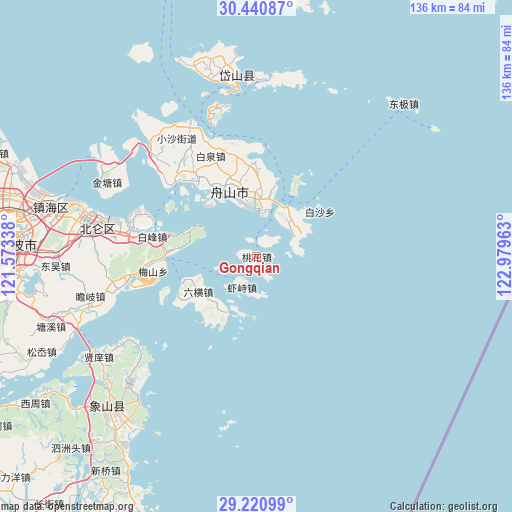
Gongqian GPS coordinates[2]
29° 49' 58.044" North, 122° 16' 35.4" East
| Map corner | latitude | longitude |
|---|---|---|
| Upper-left | 30.44087°, | 121.57338° |
| Center: | 29.83279°, | 122.2765° |
| Lower-right: | 29.22099°, | 122.97963° |
| Map W x H: | 135.6×135.6 km | = 84.3×84.3mi |
| max Lat: | 53.31946° ⇑56% North |
| Gongqian: | 29.83279° |
| min Lat: | ⇓44% South 18.22056° |
| min Long | Gongqian | max Long |
| 75.07348° | 122.2765° | 134.28917° |
| W 91.7%⇐ | ⇒8.3% E |
Elevation
Elevation of Gongqian is 14 m = 46 ft, and this is 470.8 m = 1545 ft below average elevation for this country.
| Max E: |
5622 m = 18445 ft | 86.2% |
| Avg. | 484.8 m = 1591 ft | |
| Gongqian | 14 m = 46 ft | |
Min E: |
-3 m = -10 ft | 13.8% |
See also: China elevation on elevation.city.
Geographical zone
Gongqian is located in North temperate zone (between Tropic of Cancer and the Arctic Circle). Distance of this Northern Tropic circle is 711.2 km =441.9 mi to South.| Distance of | km | miles | from Gongqian |
|---|---|---|---|
| North Pole | 6690 | 4157 | to North |
| Arctic Circle | 4084.1 | 2537.7 | to North |
| Tropic Cancer | 711.2 | 441.9 | to South |
| Equator | 3317.1 | 2061.1 | to South |


Nearby cities:
15 places around Gongqian: (largest is in red/bold)
• Baifeng
27.9 km =17.3 mi,  280°
280°
• Baiquan
29.1 km =18.1 mi,  335°
335°
• Beichan
26.6 km =16.5 mi,  348°
348°
• Dadong’ao
14.7 km =9.1 mi,  47°
47°
• Daotouzui
26.6 km =16.5 mi,  247°
247°
• Goushan
16.2 km =10.1 mi,  356°
356°
• Jiguan
5.6 km =3.5 mi,  20°
20°
• Lincheng
19.6 km =12.2 mi, 338°
• Liuheng
18.9 km =11.7 mi,  238°
238°
• Li’ao
28 km =17.4 mi,  262°
262°
• Putuoshan
19.8 km =12.3 mi,  30°
30°
• Shenjiamen
14 km =8.7 mi,  8°
8°
• Xiazhi
9.4 km =5.8 mi,  204°
204°
• Zhanmao
21.6 km =13.4 mi,  1°
1°
• Zhoushan
18.7 km =11.6 mi, 338°
Sources, notices
• [Note1] Compared only with cities in China existing in our database
• [Src1] Map data: © OpenStreetMap contributors (CC-BY-SA)
• [Src2] Other city data from geonames.org with taken over terms of usage.
• [Src3] Geographical zone / Annual Mean Temperature by Robert A. Rohde @ Wikipedia
