Putuoshan geodata
Putuoshan (Zhejiang) is a seat of a fourth-order administrative division; located in China in Asia/Shanghai (GMT+8) time zone. In our database, there are 1268 cities with bigger population. Compared to other cities in China, 54.2% of cities are located further ↑North; 91.9% of cities are located further ←West and 84.9% of cities have higher elevation than Putuoshan. Note1


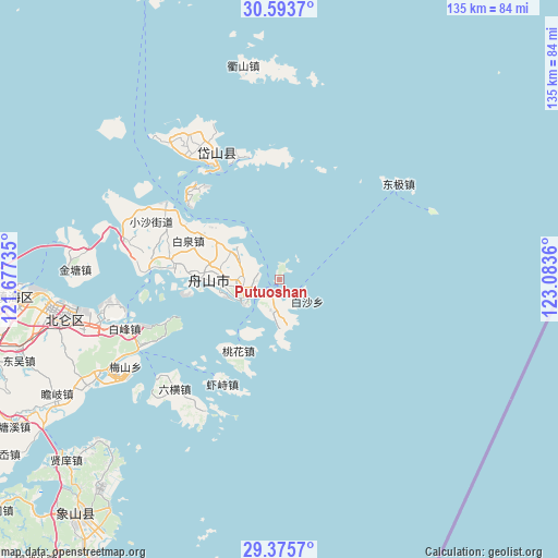
Putuoshan GPS coordinates[2]
29° 59' 11.652" North, 122° 22' 49.692" East
| Map corner | latitude | longitude |
|---|---|---|
| Upper-left | 30.5937°, | 121.67735° |
| Center: | 29.98657°, | 122.38047° |
| Lower-right: | 29.3757°, | 123.0836° |
| Map W x H: | 135.4×135.4 km | = 84.1×84.1mi |
| max Lat: | 53.31946° ⇑54.2% North |
| Putuoshan: | 29.98657° |
| min Lat: | ⇓45.8% South 18.22056° |
| min Long | Putuoshan | max Long |
| 75.07348° | 122.38047° | 134.28917° |
| W 91.9%⇐ | ⇒8.1% E |
Elevation
Elevation of Putuoshan is 16 m = 52 ft, and this is 468.8 m = 1538 ft below average elevation for this country.
| Max E: |
5622 m = 18445 ft | 84.9% |
| Avg. | 484.8 m = 1591 ft | |
| Putuoshan | 16 m = 52 ft | |
Min E: |
-3 m = -10 ft | 15.1% |
See also: China elevation on elevation.city.
Geographical zone
Putuoshan is located in North temperate zone (between Tropic of Cancer and the Arctic Circle). Distance of this Northern Tropic circle is 728.3 km =452.5 mi to South.| Distance of | km | miles | from Putuoshan |
|---|---|---|---|
| North Pole | 6672.9 | 4146.3 | to North |
| Arctic Circle | 4067 | 2527.1 | to North |
| Tropic Cancer | 728.3 | 452.5 | to South |
| Equator | 3334.2 | 2071.8 | to South |


Nearby cities:
15 places around Putuoshan: (largest is in red/bold)
• Baiquan
24 km =14.9 mi,  293°
293°
• Beichan
17.9 km =11.1 mi,  300°
300°
• Changtu
30.7 km =19.1 mi,  345°
345°
• Dadong’ao
7.2 km =4.5 mi,  173°
173°
• Ganlan
26.8 km =16.7 mi, 298°
• Gongqian
19.8 km =12.3 mi,  210°
210°
• Goushan
11.1 km =6.9 mi,  264°
264°
• Jiguan
14.4 km =8.9 mi, 214°
• Lincheng
17.4 km =10.8 mi,  273°
273°
• Shenjiamen
8.6 km =5.3 mi,  247°
247°
• Xiazhi
29.2 km =18.1 mi, 208°
• Xiushan
30.4 km =18.9 mi,  317°
317°
• Yancang
31.6 km =19.6 mi,  279°
279°
• Zhanmao
10.4 km =6.5 mi, 295°
• Zhoushan
16.9 km =10.5 mi, 270°
Sources, notices
• [Note1] Compared only with cities in China existing in our database
• [Src1] Map data: © OpenStreetMap contributors (CC-BY-SA)
• [Src2] Other city data from geonames.org with taken over terms of usage.
• [Src3] Geographical zone / Annual Mean Temperature by Robert A. Rohde @ Wikipedia
