Wulong geodata
Wulong (Zhejiang) is a seat of a fourth-order administrative division; located in China in Asia/Shanghai (GMT+8) time zone. In our database, there are 1268 cities with bigger population. Compared to other cities in China, 52.1% of cities are located further ↓South; 92.1% of cities are located further ←West and 91.2% of cities have higher elevation than Wulong. Note1


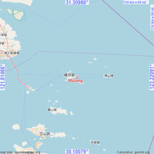
Wulong GPS coordinates[2]
30° 42' 25.992" North, 122° 31' 4.008" East
| Map corner | latitude | longitude |
|---|---|---|
| Upper-left | 31.30986°, | 121.81466° |
| Center: | 30.70722°, | 122.51778° |
| Lower-right: | 30.10079°, | 123.22091° |
| Map W x H: | 134.4×134.4 km | = 83.5×83.5mi |
| max Lat: | 53.31946° ⇑47.9% North |
| Wulong: | 30.70722° |
| min Lat: | ⇓52.1% South 18.22056° |
| min Long | Wulong | max Long |
| 75.07348° | 122.51778° | 134.28917° |
| W 92.1%⇐ | ⇒7.9% E |
Elevation
Elevation of Wulong is 9 m = 30 ft, and this is 475.8 m = 1561 ft below average elevation for this country.
| Max E: |
5622 m = 18445 ft | 91.2% |
| Avg. | 484.8 m = 1591 ft | |
| Wulong | 9 m = 30 ft | |
Min E: |
-3 m = -10 ft | 8.8% |
See also: China elevation on elevation.city.
Geographical zone
Wulong is located in North temperate zone (between Tropic of Cancer and the Arctic Circle). Distance of this Northern Tropic circle is 808.4 km =502.3 mi to South.| Distance of | km | miles | from Wulong |
|---|---|---|---|
| North Pole | 6592.7 | 4096.5 | to North |
| Arctic Circle | 3986.9 | 2477.3 | to North |
| Tropic Cancer | 808.4 | 502.3 | to South |
| Equator | 3414.3 | 2121.5 | to South |


Nearby cities:
15 places around Wulong: (largest is in red/bold)
• Caiyuan
6.6 km =4.1 mi,  286°
286°
• Changtu
54.4 km =33.8 mi,  202°
202°
• Daidaon
55.1 km =34.2 mi,  213°
213°
• Daishan
59.7 km =37.1 mi, 210°
• Daixi
59.6 km =37 mi,  219°
219°
• Dongji
59 km =36.7 mi,  164°
164°
• Dongsha
56.7 km =35.2 mi, 219°
• Gouqi
24.1 km =15 mi,  88°
88°
• Huaniao
23 km =14.3 mi,  46°
46°
• Nizhi
55.5 km =34.5 mi, 216°
• Qushan
36.3 km =22.6 mi, 218°
• Shengshan
27.7 km =17.2 mi, 87°
• Shuyuan
67.6 km =42 mi, 291°
• Xiushan
66.6 km =41.4 mi, 210°
• Yangshan
44 km =27.3 mi,  253°
253°
Sources, notices
• [Note1] Compared only with cities in China existing in our database
• [Src1] Map data: © OpenStreetMap contributors (CC-BY-SA)
• [Src2] Other city data from geonames.org with taken over terms of usage.
• [Src3] Geographical zone / Annual Mean Temperature by Robert A. Rohde @ Wikipedia
