Majiadu geodata
Majiadu (Hubei) is a seat of a fourth-order administrative division; located in China in Asia/Shanghai (GMT+8) time zone. In our database, there are 1268 cities with bigger population. Compared to other cities in China, 63% of cities are located further ↓South; 71.1% of cities are located further →East and 69.3% of cities have lower elevation than Majiadu. Note1


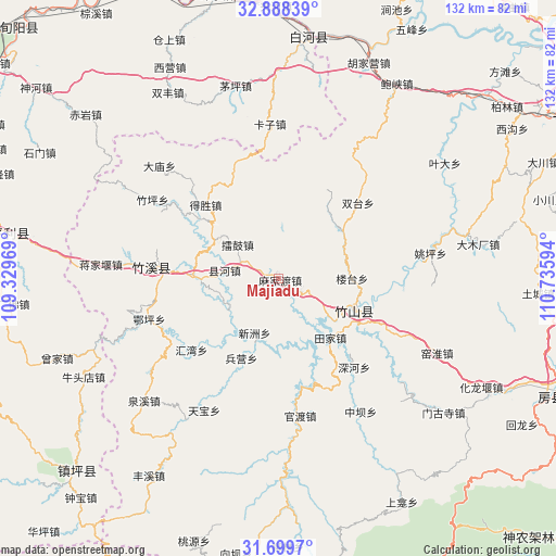
Majiadu GPS coordinates[2]
32° 17' 45.564" North, 110° 1' 58.116" East
| Map corner | latitude | longitude |
|---|---|---|
| Upper-left | 32.88839°, | 109.32969° |
| Center: | 32.29599°, | 110.03281° |
| Lower-right: | 31.6997°, | 110.73594° |
| Map W x H: | 132.2×132.2 km | = 82.1×82.1mi |
| max Lat: | 53.31946° ⇑37% North |
| Majiadu: | 32.29599° |
| min Lat: | ⇓63% South 18.22056° |
| min Long | Majiadu | max Long |
| 75.07348° | 110.03281° | 134.28917° |
| W 28.9%⇐ | ⇒71.1% E |
Elevation
Elevation of Majiadu is 397 m = 1302 ft, and this is 87.8 m = 288 ft below average elevation for this country.
| Max E: |
5622 m = 18445 ft | 30.7% |
| Avg. | 484.8 m = 1591 ft | |
| Majiadu | 397 m = 1302 ft | |
Min E: |
-3 m = -10 ft | 69.3% |
See also: China elevation on elevation.city.
Geographical zone
Majiadu is located in North temperate zone (between Tropic of Cancer and the Arctic Circle). Distance of this Northern Tropic circle is 985.1 km =612.1 mi to South.| Distance of | km | miles | from Majiadu |
|---|---|---|---|
| North Pole | 6416.1 | 3986.8 | to North |
| Arctic Circle | 3810.2 | 2367.5 | to North |
| Tropic Cancer | 985.1 | 612.1 | to South |
| Equator | 3591 | 2231.3 | to South |


Nearby cities:
15 places around Majiadu: (largest is in red/bold)
• Baofeng
2.8 km =1.7 mi,  283°
283°
• Bingying
22.4 km =13.9 mi,  202°
202°
• Desheng
24.6 km =15.3 mi,  314°
314°
• Guandu
33.4 km =20.8 mi,  172°
172°
• Huiwan
26.7 km =16.6 mi,  229°
229°
• Leigu
13 km =8.1 mi, 308°
• Qingu
24.1 km =15 mi, 306°
• Shuiping
20.9 km =13 mi,  272°
272°
• Tianjiaba
17.4 km =10.8 mi,  142°
142°
• Xianhe
13.8 km =8.6 mi,  241°
241°
• Xinzhou
14.4 km =8.9 mi,  205°
205°
• Yishui
6.3 km =3.9 mi,  120°
120°
• Zhuping
35.3 km =21.9 mi,  301°
301°
• Zhushan Chengguanzhen
20.8 km =12.9 mi,  113°
113°
• Zhuxi Chengguanzhen
29.3 km =18.2 mi, 276°
Sources, notices
• [Note1] Compared only with cities in China existing in our database
• [Src1] Map data: © OpenStreetMap contributors (CC-BY-SA)
• [Src2] Other city data from geonames.org with taken over terms of usage.
• [Src3] Geographical zone / Annual Mean Temperature by Robert A. Rohde @ Wikipedia
