Yangfeng geodata
Yangfeng (Henan) is a seat of a fourth-order administrative division; located in China in Asia/Shanghai (GMT+8) time zone. In our database, there are 1268 cities with bigger population. Compared to other cities in China, 66.7% of cities are located further ↓South; 52.2% of cities are located further →East and 63.9% of cities have higher elevation than Yangfeng. Note1


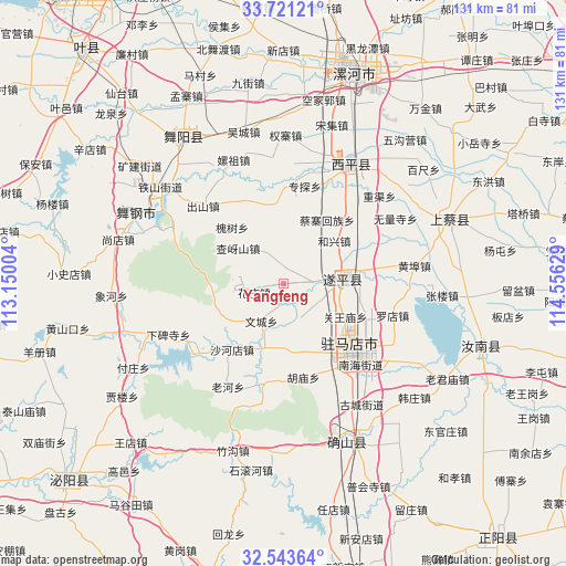
Yangfeng GPS coordinates[2]
33° 8' 3.84" North, 113° 51' 11.376" East
| Map corner | latitude | longitude |
|---|---|---|
| Upper-left | 33.72121°, | 113.15004° |
| Center: | 33.1344°, | 113.85316° |
| Lower-right: | 32.54364°, | 114.55629° |
| Map W x H: | 130.9×130.9 km | = 81.3×81.3mi |
| max Lat: | 53.31946° ⇑33.3% North |
| Yangfeng: | 33.1344° |
| min Lat: | ⇓66.7% South 18.22056° |
| min Long | Yangfeng | max Long |
| 75.07348° | 113.85316° | 134.28917° |
| W 47.8%⇐ | ⇒52.2% E |
Elevation
Elevation of Yangfeng is 78 m = 256 ft, and this is 406.8 m = 1335 ft below average elevation for this country.
| Max E: |
5622 m = 18445 ft | 63.9% |
| Avg. | 484.8 m = 1591 ft | |
| Yangfeng | 78 m = 256 ft | |
Min E: |
-3 m = -10 ft | 36.1% |
See also: China elevation on elevation.city.
Geographical zone
Yangfeng is located in North temperate zone (between Tropic of Cancer and the Arctic Circle). Distance of this Northern Tropic circle is 1078.3 km =670 mi to South.| Distance of | km | miles | from Yangfeng |
|---|---|---|---|
| North Pole | 6322.9 | 3928.9 | to North |
| Arctic Circle | 3717 | 2309.6 | to North |
| Tropic Cancer | 1078.3 | 670 | to South |
| Equator | 3684.2 | 2289.3 | to South |


Nearby cities:
15 places around Yangfeng: (largest is in red/bold)
• Chushan
25.8 km =16 mi,  313°
313°
• Hexing
15.3 km =9.5 mi,  50°
50°
• Huaishu
17.6 km =10.9 mi,  317°
317°
• Jiudian
22.7 km =14.1 mi, 307°
• Liuge
20.1 km =12.5 mi,  146°
146°
• Lumiao
24.3 km =15.1 mi,  328°
328°
• Quyang
12.8 km =8 mi,  84°
84°
• Shahedian
19.4 km =12.1 mi,  218°
218°
• Shenzhai
11.3 km =7 mi,  6°
6°
• Wencheng
10.1 km =6.3 mi,  210°
210°
• Yangzhuang
22.6 km =14 mi,  356°
356°
• Yushan
8 km =5 mi, 334°
• Zhuantan
23 km =14.3 mi, 11°
• Zhumadian
23.8 km =14.8 mi,  136°
136°
• Zhushi
8.8 km =5.5 mi,  157°
157°
Sources, notices
• [Note1] Compared only with cities in China existing in our database
• [Src1] Map data: © OpenStreetMap contributors (CC-BY-SA)
• [Src2] Other city data from geonames.org with taken over terms of usage.
• [Src3] Geographical zone / Annual Mean Temperature by Robert A. Rohde @ Wikipedia
