Zhumadian geodata
Zhumadian (Henan) is a populated place; located in China in Asia/Shanghai (GMT+8) time zone. With population of 720,000 people, there are 85 cities with bigger population in this country. Compared to other cities in China, 65.9% of cities are located further ↓South; 51.2% of cities are located further →East and 61.7% of cities have higher elevation than Zhumadian. Note1


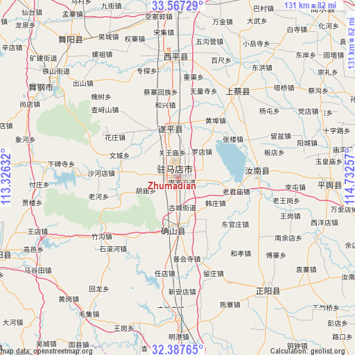
Zhumadian GPS coordinates[2]
32° 58' 45.984" North, 114° 1' 45.984" East
| Map corner | latitude | longitude |
|---|---|---|
| Upper-left | 33.56729°, | 113.32632° |
| Center: | 32.97944°, | 114.02944° |
| Lower-right: | 32.38765°, | 114.73257° |
| Map W x H: | 131.2×131.2 km | = 81.5×81.5mi |
| max Lat: | 53.31946° ⇑34.1% North |
| Zhumadian: | 32.97944° |
| min Lat: | ⇓65.9% South 18.22056° |
| min Long | Zhumadian | max Long |
| 75.07348° | 114.02944° | 134.28917° |
| W 48.8%⇐ | ⇒51.2% E |
Elevation
Elevation of Zhumadian is 89 m = 292 ft, and this is 395.8 m = 1299 ft below average elevation for this country.
| Max E: |
5622 m = 18445 ft | 61.7% |
| Avg. | 484.8 m = 1591 ft | |
| Zhumadian | 89 m = 292 ft | |
Min E: |
-3 m = -10 ft | 38.3% |
See also: Zhumadian elevation on elevation.city.
Geographical zone
Zhumadian is located in North temperate zone (between Tropic of Cancer and the Arctic Circle). Distance of this Northern Tropic circle is 1061.1 km =659.3 mi to South.| Distance of | km | miles | from Zhumadian |
|---|---|---|---|
| North Pole | 6340.1 | 3939.6 | to North |
| Arctic Circle | 3734.2 | 2320.3 | to North |
| Tropic Cancer | 1061.1 | 659.3 | to South |
| Equator | 3667 | 2278.6 | to South |


Nearby cities:
15 places around Zhumadian: (largest is in red/bold)
• Banqiao
38.1 km =23.7 mi,  273°
273°
• Chongyang
36.9 km =22.9 mi,  32°
32°
• Hexing
27.5 km =17.1 mi,  350°
350°
• Huaishu
41.4 km =25.7 mi,  316°
316°
• Laohe
30.1 km =18.7 mi,  257°
257°
• Liuge
5.4 km =3.4 mi,  275°
275°
• Panlong
19.7 km =12.2 mi,  182°
182°
• Quyang
18.7 km =11.6 mi, 348°
• Runing
30.4 km =18.9 mi,  85°
85°
• Shahedian
28.5 km =17.7 mi, 273°
• Shenzhai
32.2 km =20 mi,  332°
332°
• Wencheng
23.2 km =14.4 mi,  291°
291°
• Yangfeng
23.8 km =14.8 mi, 316°
• Yushan
31.6 km =19.6 mi, 320°
• Zhushi
16 km =9.9 mi,  304°
304°
Sources, notices
• [Note1] Compared only with cities in China existing in our database
• [Src1] Map data: © OpenStreetMap contributors (CC-BY-SA)
• [Src2] Other city data from geonames.org with taken over terms of usage.
• [Src3] Geographical zone / Annual Mean Temperature by Robert A. Rohde @ Wikipedia
