Xizhangbao geodata
Xizhangbao (Shaanxi) is a seat of a fourth-order administrative division; located in China in Asia/Shanghai (GMT+8) time zone. In our database, there are 1268 cities with bigger population. Compared to other cities in China, 72.8% of cities are located further ↓South; 78.3% of cities are located further →East and 74.6% of cities have lower elevation than Xizhangbao. Note1


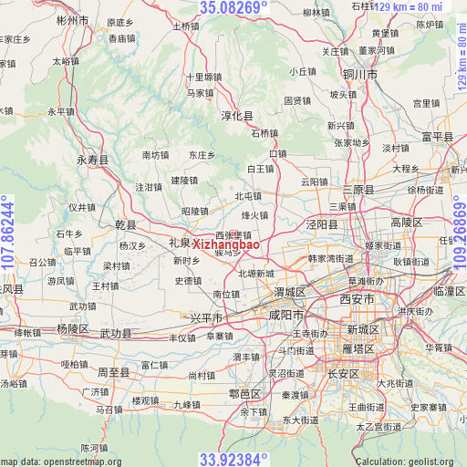
Xizhangbao GPS coordinates[2]
34° 30' 19.008" North, 108° 33' 56.016" East
| Map corner | latitude | longitude |
|---|---|---|
| Upper-left | 35.08269°, | 107.86244° |
| Center: | 34.50528°, | 108.56556° |
| Lower-right: | 33.92384°, | 109.26869° |
| Map W x H: | 128.9×128.9 km | = 80.1×80.1mi |
| max Lat: | 53.31946° ⇑27.2% North |
| Xizhangbao: | 34.50528° |
| min Lat: | ⇓72.8% South 18.22056° |
| min Long | Xizhangbao | max Long |
| 75.07348° | 108.56556° | 134.28917° |
| W 21.7%⇐ | ⇒78.3% E |
Elevation
Elevation of Xizhangbao is 514 m = 1686 ft, and this is 29.2 m = 96 ft above average elevation for this country.
| Max E: |
5622 m = 18445 ft | 25.4% |
| Xizhangbao | 514 m 1686 ft | |
| Avg. | 484.8 m = 1591 ft | |
Min E: |
-3 m = -10 ft | 74.6% |
See also: China elevation on elevation.city.
Geographical zone
Xizhangbao is located in North temperate zone (between Tropic of Cancer and the Arctic Circle). Distance of this Northern Tropic circle is 1230.7 km =764.7 mi to South.| Distance of | km | miles | from Xizhangbao |
|---|---|---|---|
| North Pole | 6170.4 | 3834.1 | to North |
| Arctic Circle | 3564.5 | 2214.9 | to North |
| Tropic Cancer | 1230.7 | 764.7 | to South |
| Equator | 3836.6 | 2384 | to South |


Nearby cities:
15 places around Xizhangbao: (largest is in red/bold)
• Beidu
16.2 km =10.1 mi,  107°
107°
• Fenghuo
7.8 km =4.8 mi,  47°
47°
• Liquan Chengguanzhen
13.3 km =8.3 mi,  258°
258°
• Mazhuang
11.2 km =7 mi,  132°
132°
• Nanwei
16.6 km =10.3 mi,  187°
187°
• Qiandong
6.8 km =4.2 mi,  75°
75°
• Qiaodi
17.8 km =11.1 mi, 50°
• Shide
17.9 km =11.1 mi,  224°
224°
• Shuangzhao
12.4 km =7.7 mi,  157°
157°
• Taiping
15.6 km =9.7 mi,  89°
89°
• Wangqiao
14.2 km =8.8 mi,  29°
29°
• Yanxia
8.1 km =5 mi,  345°
345°
• Zhaoling
12.6 km =7.8 mi,  300°
300°
• Zhaozhen
8.5 km =5.3 mi,  312°
312°
• Zhouling
18.5 km =11.5 mi, 126°
Sources, notices
• [Note1] Compared only with cities in China existing in our database
• [Src1] Map data: © OpenStreetMap contributors (CC-BY-SA)
• [Src2] Other city data from geonames.org with taken over terms of usage.
• [Src3] Geographical zone / Annual Mean Temperature by Robert A. Rohde @ Wikipedia
