Nanwei geodata
Nanwei (Shaanxi) is a seat of a fourth-order administrative division; located in China in Asia/Shanghai (GMT+8) time zone. In our database, there are 1268 cities with bigger population. Compared to other cities in China, 71.9% of cities are located further ↓South; 78.4% of cities are located further →East and 73.9% of cities have lower elevation than Nanwei. Note1


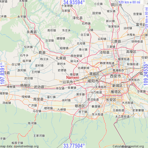
Nanwei GPS coordinates[2]
34° 21' 27" North, 108° 32' 31.992" East
| Map corner | latitude | longitude |
|---|---|---|
| Upper-left | 34.93594°, | 107.8391° |
| Center: | 34.3575°, | 108.54222° |
| Lower-right: | 33.77504°, | 109.24535° |
| Map W x H: | 129.1×129.1 km | = 80.2×80.2mi |
| max Lat: | 53.31946° ⇑28.1% North |
| Nanwei: | 34.3575° |
| min Lat: | ⇓71.9% South 18.22056° |
| min Long | Nanwei | max Long |
| 75.07348° | 108.54222° | 134.28917° |
| W 21.6%⇐ | ⇒78.4% E |
Elevation
Elevation of Nanwei is 497 m = 1631 ft, and this is 12.2 m = 40 ft above average elevation for this country.
| Max E: |
5622 m = 18445 ft | 26.1% |
| Nanwei | 497 m 1631 ft | |
| Avg. | 484.8 m = 1591 ft | |
Min E: |
-3 m = -10 ft | 73.9% |
See also: China elevation on elevation.city.
Geographical zone
Nanwei is located in North temperate zone (between Tropic of Cancer and the Arctic Circle). Distance of this Northern Tropic circle is 1214.3 km =754.5 mi to South.| Distance of | km | miles | from Nanwei |
|---|---|---|---|
| North Pole | 6186.9 | 3844.4 | to North |
| Arctic Circle | 3581 | 2225.1 | to North |
| Tropic Cancer | 1214.3 | 754.5 | to South |
| Equator | 3820.2 | 2373.8 | to South |


Nearby cities:
15 places around Nanwei: (largest is in red/bold)
• Fuzhai
11.7 km =7.3 mi,  189°
189°
• Gudu
13.9 km =8.6 mi,  95°
95°
• Maquan
6.8 km =4.2 mi,  123°
123°
• Mazhuang
13.6 km =8.5 mi,  49°
49°
• Nanshi
7.3 km =4.5 mi,  272°
272°
• Qindu
15.3 km =9.5 mi, 96°
• Shide
11.2 km =7 mi,  289°
289°
• Shuangzhao
8.5 km =5.3 mi, 54°
• Tianfu
11.4 km =7.1 mi,  155°
155°
• Weibin
10.6 km =6.6 mi, 115°
• Wujiabao
14.5 km =9 mi,  94°
94°
• Xianyang
14.9 km =9.3 mi, 98°
• Xicheng
10.7 km =6.6 mi,  239°
239°
• Xiwu
7.1 km =4.4 mi, 161°
• Zhuangtou
13.9 km =8.6 mi,  216°
216°
Sources, notices
• [Note1] Compared only with cities in China existing in our database
• [Src1] Map data: © OpenStreetMap contributors (CC-BY-SA)
• [Src2] Other city data from geonames.org with taken over terms of usage.
• [Src3] Geographical zone / Annual Mean Temperature by Robert A. Rohde @ Wikipedia
