Dongcheng geodata
Dongcheng (Hainan) is a seat of a fourth-order administrative division; located in China in Asia/Shanghai (GMT+8) time zone. In our database, there are 1268 cities with bigger population. Compared to other cities in China, 99% of cities are located further ↑North; 74.1% of cities are located further →East and 77.2% of cities have higher elevation than Dongcheng. Note1


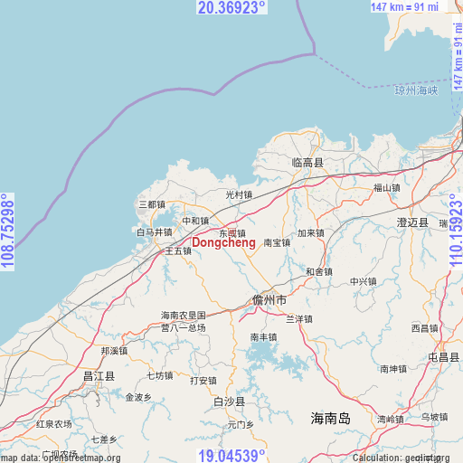
Dongcheng GPS coordinates[2]
19° 42' 31.248" North, 109° 27' 21.96" East
| Map corner | latitude | longitude |
|---|---|---|
| Upper-left | 20.36923°, | 108.75298° |
| Center: | 19.70868°, | 109.4561° |
| Lower-right: | 19.04539°, | 110.15923° |
| Map W x H: | 147.2×147.2 km | = 91.5×91.5mi |
| max Lat: | 53.31946° ⇑99% North |
| Dongcheng: | 19.70868° |
| min Lat: | ⇓1% South 18.22056° |
| min Long | Dongcheng | max Long |
| 75.07348° | 109.4561° | 134.28917° |
| W 25.9%⇐ | ⇒74.1% E |
Elevation
Elevation of Dongcheng is 32 m = 105 ft, and this is 452.8 m = 1486 ft below average elevation for this country.
| Max E: |
5622 m = 18445 ft | 77.2% |
| Avg. | 484.8 m = 1591 ft | |
| Dongcheng | 32 m = 105 ft | |
Min E: |
-3 m = -10 ft | 22.8% |
See also: China elevation on elevation.city.
Geographical zone
Dongcheng is located in North Torrid zone (between Equator and Tropic of Cancer). Distance of this Northern Tropic circle is 414.5 km =257.6 mi to North.| Distance of | km | miles | from Dongcheng |
|---|---|---|---|
| North Pole | 7815.7 | 4856.4 | to North |
| Arctic Circle | 5209.8 | 3237.2 | to North |
| Tropic Cancer | 414.5 | 257.6 | to North |
| Equator | 2191.4 | 1361.7 | to South |


Nearby cities:
15 places around Dongcheng: (largest is in red/bold)
• Baimajing
24.9 km =15.5 mi,  270°
270°
• Bolian
26.4 km =16.4 mi,  47°
47°
• Dacheng
23.1 km =14.4 mi,  196°
196°
• Eman
26.1 km =16.2 mi,  309°
309°
• Guangcun
12.3 km =7.6 mi,  10°
10°
• Jialai
25.1 km =15.6 mi,  90°
90°
• Mutang
16 km =9.9 mi, 313°
• Nada
24.3 km =15.1 mi,  148°
148°
• Nanbao
14.9 km =9.3 mi,  101°
101°
• Sandu
26.8 km =16.7 mi,  289°
289°
• Tiaolou
26.9 km =16.7 mi,  17°
17°
• Wangwu
18.3 km =11.4 mi,  251°
251°
• Xinying
21.7 km =13.5 mi, 19°
• Xinzhou
15.2 km =9.4 mi, 272°
• Zhonghe
12.2 km =7.6 mi, 288°
Sources, notices
• [Note1] Compared only with cities in China existing in our database
• [Src1] Map data: © OpenStreetMap contributors (CC-BY-SA)
• [Src2] Other city data from geonames.org with taken over terms of usage.
• [Src3] Geographical zone / Annual Mean Temperature by Robert A. Rohde @ Wikipedia
