Shatian geodata
Shatian (Guangdong) is a seat of a fourth-order administrative division; located in China in Asia/Urumqi (GMT+6) time zone. In our database, there are 1268 cities with bigger population. Compared to other cities in China, 97.4% of cities are located further ↑North; 68.2% of cities are located further →East and 75.3% of cities have higher elevation than Shatian. Note1


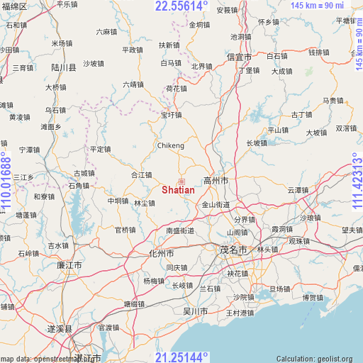
Shatian GPS coordinates[2]
21° 54' 19.008" North, 110° 43' 12" East
| Map corner | latitude | longitude |
|---|---|---|
| Upper-left | 22.55614°, | 110.01688° |
| Center: | 21.90528°, | 110.72° |
| Lower-right: | 21.25144°, | 111.42313° |
| Map W x H: | 145.1×145.1 km | = 90.2×90.2mi |
| max Lat: | 53.31946° ⇑97.4% North |
| Shatian: | 21.90528° |
| min Lat: | ⇓2.6% South 18.22056° |
| min Long | Shatian | max Long |
| 75.07348° | 110.72° | 134.28917° |
| W 31.8%⇐ | ⇒68.2% E |
Elevation
Elevation of Shatian is 36 m = 118 ft, and this is 448.8 m = 1472 ft below average elevation for this country.
| Max E: |
5622 m = 18445 ft | 75.3% |
| Avg. | 484.8 m = 1591 ft | |
| Shatian | 36 m = 118 ft | |
Min E: |
-3 m = -10 ft | 24.7% |
See also: China elevation on elevation.city.
Geographical zone
Shatian is located in North Torrid zone (between Equator and Tropic of Cancer). Distance of this Northern Tropic circle is 170.3 km =105.8 mi to North.| Distance of | km | miles | from Shatian |
|---|---|---|---|
| North Pole | 7571.4 | 4704.6 | to North |
| Arctic Circle | 4965.5 | 3085.4 | to North |
| Tropic Cancer | 170.3 | 105.8 | to North |
| Equator | 2435.6 | 1513.4 | to South |


Nearby cities:
15 places around Shatian: (largest is in red/bold)
• Baoguang
12.5 km =7.8 mi,  78°
78°
• Gaozhou
13.5 km =8.4 mi,  73°
73°
• Hejiang
17 km =10.6 mi,  281°
281°
• Hetang
11.7 km =7.3 mi,  356°
356°
• Jianghu
12.5 km =7.8 mi,  252°
252°
• Jinshan
14.4 km =8.9 mi,  122°
122°
• Linchen
17.1 km =10.6 mi,  241°
241°
• Nansheng
19.2 km =11.9 mi,  183°
183°
• Nantang
18.8 km =11.7 mi,  22°
22°
• Nawu
17.5 km =10.9 mi,  308°
308°
• Panzhou
13.5 km =8.4 mi, 80°
• Shanmei
16.1 km =10 mi, 79°
• Shigu
10 km =6.2 mi,  152°
152°
• Shiziling
10.7 km =6.6 mi,  99°
99°
• Zhenjiang
4.4 km =2.7 mi,  199°
199°
Sources, notices
• [Note1] Compared only with cities in China existing in our database
• [Src1] Map data: © OpenStreetMap contributors (CC-BY-SA)
• [Src2] Other city data from geonames.org with taken over terms of usage.
• [Src3] Geographical zone / Annual Mean Temperature by Robert A. Rohde @ Wikipedia
