Fulong geodata
Fulong (Hainan) is a seat of a fourth-order administrative division; located in China in Asia/Shanghai (GMT+8) time zone. In our database, there are 1268 cities with bigger population. Compared to other cities in China, 99.3% of cities are located further ↑North; 74.1% of cities are located further →East and 60.2% of cities have lower elevation than Fulong. Note1


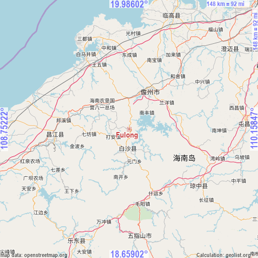
Fulong GPS coordinates[2]
19° 19' 25.932" North, 109° 27' 19.224" East
| Map corner | latitude | longitude |
|---|---|---|
| Upper-left | 19.98602°, | 108.75222° |
| Center: | 19.32387°, | 109.45534° |
| Lower-right: | 18.65902°, | 110.15847° |
| Map W x H: | 147.5×147.6 km | = 91.7×91.7mi |
| max Lat: | 53.31946° ⇑99.3% North |
| Fulong: | 19.32387° |
| min Lat: | ⇓0.7% South 18.22056° |
| min Long | Fulong | max Long |
| 75.07348° | 109.45534° | 134.28917° |
| W 25.9%⇐ | ⇒74.1% E |
Elevation
Elevation of Fulong is 262 m = 860 ft, and this is 222.8 m = 731 ft below average elevation for this country.
| Max E: |
5622 m = 18445 ft | 39.8% |
| Avg. | 484.8 m = 1591 ft | |
| Fulong | 262 m = 860 ft | |
Min E: |
-3 m = -10 ft | 60.2% |
See also: China elevation on elevation.city.
Geographical zone
Fulong is located in North Torrid zone (between Equator and Tropic of Cancer). Distance of this Northern Tropic circle is 457.3 km =284.2 mi to North.| Distance of | km | miles | from Fulong |
|---|---|---|---|
| North Pole | 7858.4 | 4883 | to North |
| Arctic Circle | 5252.6 | 3263.8 | to North |
| Tropic Cancer | 457.3 | 284.2 | to North |
| Equator | 2148.6 | 1335.1 | to South |


Nearby cities:
15 places around Fulong: (largest is in red/bold)
• Baisha
14.7 km =9.1 mi,  183°
183°
• Dacheng
21.6 km =13.4 mi,  342°
342°
• Da’an
10.1 km =6.3 mi,  244°
244°
• Heqing
29.4 km =18.3 mi,  39°
39°
• Jinbo
31.3 km =19.4 mi,  252°
252°
• Lanyang
26.4 km =16.4 mi,  54°
54°
• Limushan
34.9 km =21.7 mi,  100°
100°
• Nada
25.6 km =15.9 mi,  30°
30°
• Nanfeng
13.8 km =8.6 mi, 46°
• Nankai
27.6 km =17.1 mi,  190°
190°
• Qifang
23.2 km =14.4 mi,  263°
263°
• Xishui
16.6 km =10.3 mi,  138°
138°
• Yacha
10.4 km =6.5 mi, 184°
• Yaxing
24.5 km =15.2 mi,  304°
304°
• Yuanmen
18.6 km =11.6 mi,  171°
171°
Sources, notices
• [Note1] Compared only with cities in China existing in our database
• [Src1] Map data: © OpenStreetMap contributors (CC-BY-SA)
• [Src2] Other city data from geonames.org with taken over terms of usage.
• [Src3] Geographical zone / Annual Mean Temperature by Robert A. Rohde @ Wikipedia
