Qifang geodata
Qifang (Hainan) is a seat of a fourth-order administrative division; located in China in Asia/Shanghai (GMT+8) time zone. In our database, there are 1268 cities with bigger population. Compared to other cities in China, 99.4% of cities are located further ↑North; 75.2% of cities are located further →East and 50.6% of cities have higher elevation than Qifang. Note1


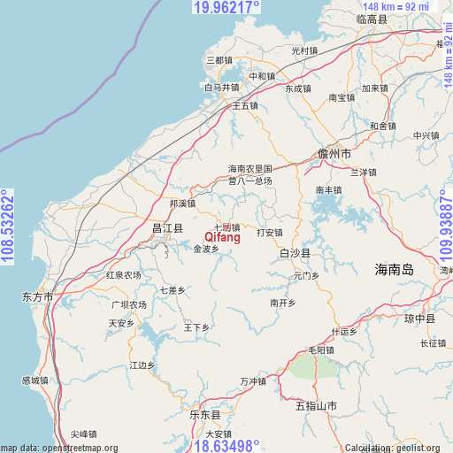
Qifang GPS coordinates[2]
19° 17' 59.712" North, 109° 14' 8.664" East
| Map corner | latitude | longitude |
|---|---|---|
| Upper-left | 19.96217°, | 108.53262° |
| Center: | 19.29992°, | 109.23574° |
| Lower-right: | 18.63498°, | 109.93887° |
| Map W x H: | 147.6×147.6 km | = 91.7×91.7mi |
| max Lat: | 53.31946° ⇑99.4% North |
| Qifang: | 19.29992° |
| min Lat: | ⇓0.6% South 18.22056° |
| min Long | Qifang | max Long |
| 75.07348° | 109.23574° | 134.28917° |
| W 24.8%⇐ | ⇒75.2% E |
Elevation
Elevation of Qifang is 159 m = 522 ft, and this is 325.8 m = 1069 ft below average elevation for this country.
| Max E: |
5622 m = 18445 ft | 50.6% |
| Avg. | 484.8 m = 1591 ft | |
| Qifang | 159 m = 522 ft | |
Min E: |
-3 m = -10 ft | 49.4% |
See also: China elevation on elevation.city.
Geographical zone
Qifang is located in North Torrid zone (between Equator and Tropic of Cancer). Distance of this Northern Tropic circle is 460 km =285.8 mi to North.| Distance of | km | miles | from Qifang |
|---|---|---|---|
| North Pole | 7861.1 | 4884.7 | to North |
| Arctic Circle | 5255.2 | 3265.4 | to North |
| Tropic Cancer | 460 | 285.8 | to North |
| Equator | 2145.9 | 1333.4 | to South |


Nearby cities:
15 places around Qifang: (largest is in red/bold)
• Baisha
25.3 km =15.7 mi,  118°
118°
• Bangxi
16.5 km =10.3 mi,  298°
298°
• Chahe
32.1 km =19.9 mi,  256°
256°
• Dacheng
28.5 km =17.7 mi,  35°
35°
• Da’an
14 km =8.7 mi,  96°
96°
• Fulong
23.2 km =14.4 mi,  83°
83°
• Jinbo
9.5 km =5.9 mi,  226°
226°
• Nankai
30.5 km =19 mi,  143°
143°
• Qicha
27.2 km =16.9 mi,  220°
220°
• Rongbang
19.5 km =12.1 mi,  326°
326°
• Shilu
20.1 km =12.5 mi, 257°
• Shiyuetian
30.3 km =18.8 mi,  276°
276°
• Yacha
23.5 km =14.6 mi,  109°
109°
• Yaxing
16.7 km =10.4 mi,  9°
9°
• Yuanmen
30.3 km =18.8 mi, 121°
Sources, notices
• [Note1] Compared only with cities in China existing in our database
• [Src1] Map data: © OpenStreetMap contributors (CC-BY-SA)
• [Src2] Other city data from geonames.org with taken over terms of usage.
• [Src3] Geographical zone / Annual Mean Temperature by Robert A. Rohde @ Wikipedia
