Jinxiang geodata
Jinxiang (Guangdong) is a seat of a fourth-order administrative division; located in China in Asia/Shanghai (GMT+8) time zone. In our database, there are 1268 cities with bigger population. Compared to other cities in China, 95.1% of cities are located further ↑North; 58.4% of cities are located further ←West and 97.2% of cities have higher elevation than Jinxiang. Note1


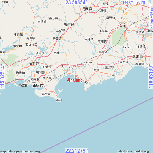
Jinxiang GPS coordinates[2]
22° 51' 43.956" North, 115° 43' 41.736" East
| Map corner | latitude | longitude |
|---|---|---|
| Upper-left | 23.50854°, | 115.02514° |
| Center: | 22.86221°, | 115.72826° |
| Lower-right: | 22.21279°, | 116.43139° |
| Map W x H: | 144.1×144.1 km | = 89.5×89.5mi |
| max Lat: | 53.31946° ⇑95.1% North |
| Jinxiang: | 22.86221° |
| min Lat: | ⇓4.9% South 18.22056° |
| min Long | Jinxiang | max Long |
| 75.07348° | 115.72826° | 134.28917° |
| W 58.4%⇐ | ⇒41.6% E |
Elevation
Elevation of Jinxiang is 5 m = 16 ft, and this is 479.8 m = 1574 ft below average elevation for this country.
| Max E: |
5622 m = 18445 ft | 97.2% |
| Avg. | 484.8 m = 1591 ft | |
| Jinxiang | 5 m = 16 ft | |
Min E: |
-3 m = -10 ft | 2.8% |
See also: China elevation on elevation.city.
Geographical zone
Jinxiang is located in North Torrid zone (between Equator and Tropic of Cancer). Distance of this Northern Tropic circle is 63.9 km =39.7 mi to North.| Distance of | km | miles | from Jinxiang |
|---|---|---|---|
| North Pole | 7465 | 4638.5 | to North |
| Arctic Circle | 4859.1 | 3019.3 | to North |
| Tropic Cancer | 63.9 | 39.7 | to North |
| Equator | 2542 | 1579.5 | to South |


Nearby cities:
15 places around Jinxiang: (largest is in red/bold)
• Bawan
19.2 km =11.9 mi,  7°
7°
• Beiyang
22.3 km =13.9 mi,  33°
33°
• Bomei
11.4 km =7.1 mi, 32°
• Chengdong
11.8 km =7.3 mi,  327°
327°
• Dahu
16.6 km =10.3 mi,  260°
260°
• Donghai
12.8 km =8 mi,  316°
316°
• Hedong
15.4 km =9.6 mi, 328°
• Hexi
18.6 km =11.6 mi,  311°
311°
• Hudong
23.3 km =14.5 mi,  102°
102°
• Jieshi
12 km =7.5 mi,  118°
118°
• Nantang
19.7 km =12.2 mi,  74°
74°
• Neihu
16.3 km =10.1 mi,  37°
37°
• Qiaochong
9.6 km =6 mi,  47°
47°
• Shangying
17 km =10.6 mi,  278°
278°
• Tanxi
18.9 km =11.7 mi,  295°
295°
Sources, notices
• [Note1] Compared only with cities in China existing in our database
• [Src1] Map data: © OpenStreetMap contributors (CC-BY-SA)
• [Src2] Other city data from geonames.org with taken over terms of usage.
• [Src3] Geographical zone / Annual Mean Temperature by Robert A. Rohde @ Wikipedia
