Qiaochong geodata
Qiaochong (Guangdong) is a seat of a fourth-order administrative division; located in China in Asia/Shanghai (GMT+8) time zone. In our database, there are 1268 cities with bigger population. Compared to other cities in China, 94.9% of cities are located further ↑North; 58.9% of cities are located further ←West and 92.7% of cities have higher elevation than Qiaochong. Note1


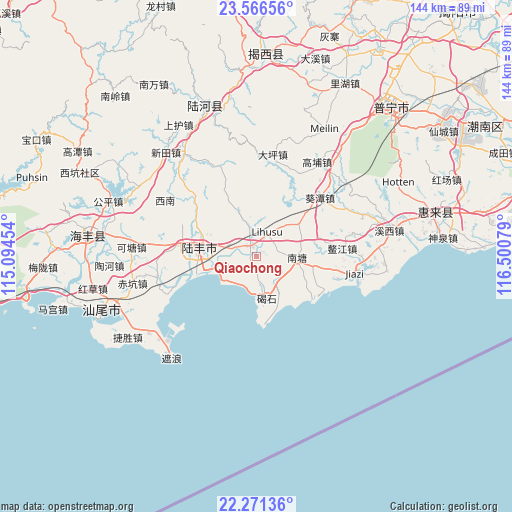
Qiaochong GPS coordinates[2]
22° 55' 13.836" North, 115° 47' 51.576" East
| Map corner | latitude | longitude |
|---|---|---|
| Upper-left | 23.56656°, | 115.09454° |
| Center: | 22.92051°, | 115.79766° |
| Lower-right: | 22.27136°, | 116.50079° |
| Map W x H: | 144×144 km | = 89.5×89.5mi |
| max Lat: | 53.31946° ⇑94.9% North |
| Qiaochong: | 22.92051° |
| min Lat: | ⇓5.1% South 18.22056° |
| min Long | Qiaochong | max Long |
| 75.07348° | 115.79766° | 134.28917° |
| W 58.9%⇐ | ⇒41.1% E |
Elevation
Elevation of Qiaochong is 8 m = 26 ft, and this is 476.8 m = 1564 ft below average elevation for this country.
| Max E: |
5622 m = 18445 ft | 92.7% |
| Avg. | 484.8 m = 1591 ft | |
| Qiaochong | 8 m = 26 ft | |
Min E: |
-3 m = -10 ft | 7.3% |
See also: China elevation on elevation.city.
Geographical zone
Qiaochong is located in North Torrid zone (between Equator and Tropic of Cancer). Distance of this Northern Tropic circle is 57.4 km =35.7 mi to North.| Distance of | km | miles | from Qiaochong |
|---|---|---|---|
| North Pole | 7458.5 | 4634.5 | to North |
| Arctic Circle | 4852.7 | 3015.3 | to North |
| Tropic Cancer | 57.4 | 35.7 | to North |
| Equator | 2548.5 | 1583.6 | to South |


Nearby cities:
15 places around Qiaochong: (largest is in red/bold)
• Bawan
13.4 km =8.3 mi,  339°
339°
• Beiyang
13.2 km =8.2 mi,  22°
22°
• Bomei
3.4 km =2.1 mi, 341°
• Chengdong
13.8 km =8.6 mi,  284°
284°
• Da’an
23.2 km =14.4 mi,  315°
315°
• Donggang
15.8 km =9.8 mi,  62°
62°
• Donghai
16.2 km =10.1 mi, 280°
• Hedong
16.6 km =10.3 mi,  293°
293°
• Hexi
21.9 km =13.6 mi, 285°
• Hudong
19.4 km =12.1 mi,  126°
126°
• Jieshi
12.7 km =7.9 mi,  164°
164°
• Jinxiang
9.6 km =6 mi,  227°
227°
• Nantang
11.9 km =7.4 mi,  95°
95°
• Neihu
7 km =4.3 mi, 22°
• Shangying
24.2 km =15 mi,  260°
260°
Sources, notices
• [Note1] Compared only with cities in China existing in our database
• [Src1] Map data: © OpenStreetMap contributors (CC-BY-SA)
• [Src2] Other city data from geonames.org with taken over terms of usage.
• [Src3] Geographical zone / Annual Mean Temperature by Robert A. Rohde @ Wikipedia
