Gaoxiang geodata
Gaoxiang (Zhejiang) is a seat of a fourth-order administrative division; located in China in Asia/Shanghai (GMT+8) time zone. In our database, there are 1268 cities with bigger population. Compared to other cities in China, 54.7% of cities are located further ↑North; 79.4% of cities are located further ←West and 67.2% of cities have higher elevation than Gaoxiang. Note1


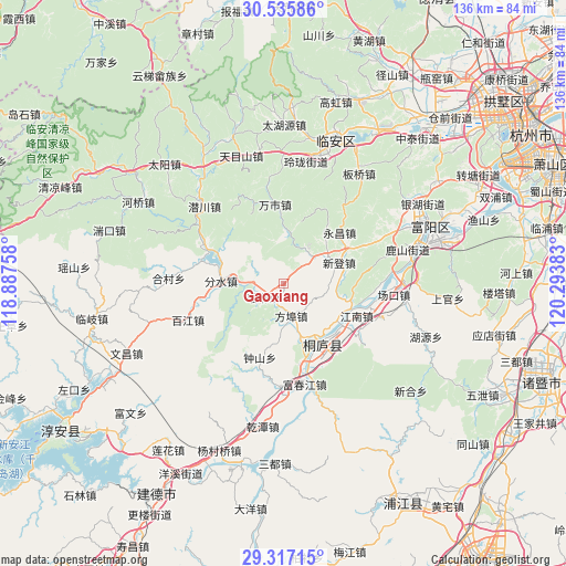
Gaoxiang GPS coordinates[2]
29° 55' 42.132" North, 119° 35' 26.52" East
| Map corner | latitude | longitude |
|---|---|---|
| Upper-left | 30.53586°, | 118.88758° |
| Center: | 29.92837°, | 119.5907° |
| Lower-right: | 29.31715°, | 120.29383° |
| Map W x H: | 135.5×135.5 km | = 84.2×84.2mi |
| max Lat: | 53.31946° ⇑54.7% North |
| Gaoxiang: | 29.92837° |
| min Lat: | ⇓45.3% South 18.22056° |
| min Long | Gaoxiang | max Long |
| 75.07348° | 119.5907° | 134.28917° |
| W 79.4%⇐ | ⇒20.6% E |
Elevation
Elevation of Gaoxiang is 64 m = 210 ft, and this is 420.8 m = 1381 ft below average elevation for this country.
| Max E: |
5622 m = 18445 ft | 67.2% |
| Avg. | 484.8 m = 1591 ft | |
| Gaoxiang | 64 m = 210 ft | |
Min E: |
-3 m = -10 ft | 32.8% |
See also: China elevation on elevation.city.
Geographical zone
Gaoxiang is located in North temperate zone (between Tropic of Cancer and the Arctic Circle). Distance of this Northern Tropic circle is 721.8 km =448.5 mi to South.| Distance of | km | miles | from Gaoxiang |
|---|---|---|---|
| North Pole | 6679.3 | 4150.3 | to North |
| Arctic Circle | 4073.5 | 2531.2 | to North |
| Tropic Cancer | 721.8 | 448.5 | to South |
| Equator | 3327.7 | 2067.7 | to South |


Nearby cities:
15 places around Gaoxiang: (largest is in red/bold)
• Bipu
6.4 km =4 mi,  263°
263°
• Dongqiao
16.4 km =10.2 mi,  357°
357°
• Eshan
14.3 km =8.9 mi,  187°
187°
• Fangbu
8 km =5 mi,  166°
166°
• Fenshui
15.4 km =9.6 mi,  270°
270°
• Jiuxian
14.4 km =8.9 mi, 167°
• Leping
20.8 km =12.9 mi,  296°
296°
• Shifu
20.8 km =12.9 mi,  117°
117°
• Wanshi
18.9 km =11.7 mi,  353°
353°
• Xindeng
14.1 km =8.8 mi,  70°
70°
• Xukou
9.6 km =6 mi,  49°
49°
• Yaolin
6 km =3.7 mi,  236°
236°
• Yinzhu
17.8 km =11.1 mi,  289°
289°
• Yongchang
18.3 km =11.4 mi, 48°
• Zhaixi
17.8 km =11.1 mi,  111°
111°
Sources, notices
• [Note1] Compared only with cities in China existing in our database
• [Src1] Map data: © OpenStreetMap contributors (CC-BY-SA)
• [Src2] Other city data from geonames.org with taken over terms of usage.
• [Src3] Geographical zone / Annual Mean Temperature by Robert A. Rohde @ Wikipedia
