Xukou geodata
Xukou (Zhejiang) is a seat of a fourth-order administrative division; located in China in Asia/Shanghai (GMT+8) time zone. In our database, there are 1268 cities with bigger population. Compared to other cities in China, 54.2% of cities are located further ↑North; 79.8% of cities are located further ←West and 78.8% of cities have higher elevation than Xukou. Note1


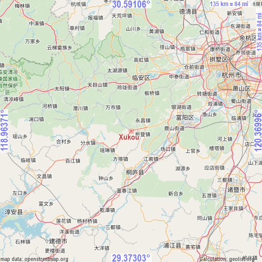
Xukou GPS coordinates[2]
29° 59' 2.076" North, 119° 40' 0.588" East
| Map corner | latitude | longitude |
|---|---|---|
| Upper-left | 30.59106°, | 118.96371° |
| Center: | 29.98391°, | 119.66683° |
| Lower-right: | 29.37303°, | 120.36996° |
| Map W x H: | 135.4×135.4 km | = 84.1×84.1mi |
| max Lat: | 53.31946° ⇑54.2% North |
| Xukou: | 29.98391° |
| min Lat: | ⇓45.8% South 18.22056° |
| min Long | Xukou | max Long |
| 75.07348° | 119.66683° | 134.28917° |
| W 79.8%⇐ | ⇒20.2% E |
Elevation
Elevation of Xukou is 29 m = 95 ft, and this is 455.8 m = 1495 ft below average elevation for this country.
| Max E: |
5622 m = 18445 ft | 78.8% |
| Avg. | 484.8 m = 1591 ft | |
| Xukou | 29 m = 95 ft | |
Min E: |
-3 m = -10 ft | 21.2% |
See also: China elevation on elevation.city.
Geographical zone
Xukou is located in North temperate zone (between Tropic of Cancer and the Arctic Circle). Distance of this Northern Tropic circle is 728 km =452.4 mi to South.| Distance of | km | miles | from Xukou |
|---|---|---|---|
| North Pole | 6673.2 | 4146.5 | to North |
| Arctic Circle | 4067.3 | 2527.3 | to North |
| Tropic Cancer | 728 | 452.4 | to South |
| Equator | 3333.9 | 2071.6 | to South |


Nearby cities:
15 places around Xukou: (largest is in red/bold)
• Bipu
15.3 km =9.5 mi,  243°
243°
• Chunjian
18.5 km =11.5 mi,  56°
56°
• Dongqiao
13 km =8.1 mi,  321°
321°
• Fangbu
15.1 km =9.4 mi,  201°
201°
• Gaoxiang
9.6 km =6 mi,  229°
229°
• Jiuxian
20.6 km =12.8 mi,  191°
191°
• Sankou
14.7 km =9.1 mi,  29°
29°
• Shanggan
21.5 km =13.4 mi,  11°
11°
• Shifu
19.3 km =12 mi,  144°
144°
• Wanshi
15.8 km =9.8 mi, 323°
• Xindeng
6.1 km =3.8 mi,  103°
103°
• Xintong
16.6 km =10.3 mi,  121°
121°
• Yaolin
15.5 km =9.6 mi, 232°
• Yongchang
8.7 km =5.4 mi,  46°
46°
• Zhaixi
15.7 km =9.8 mi, 144°
Sources, notices
• [Note1] Compared only with cities in China existing in our database
• [Src1] Map data: © OpenStreetMap contributors (CC-BY-SA)
• [Src2] Other city data from geonames.org with taken over terms of usage.
• [Src3] Geographical zone / Annual Mean Temperature by Robert A. Rohde @ Wikipedia
