Banjiang geodata
Banjiang (Guangdong) is a seat of a fourth-order administrative division; located in China in Asia/Shanghai (GMT+8) time zone. In our database, there are 1268 cities with bigger population. Compared to other cities in China, 90.3% of cities are located further ↑North; 51.9% of cities are located further ←West and 59.7% of cities have higher elevation than Banjiang. Note1


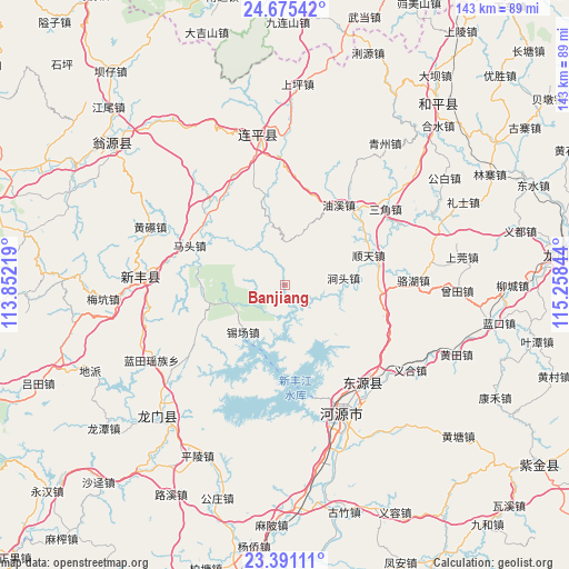
Banjiang GPS coordinates[2]
24° 2' 5.532" North, 114° 33' 19.116" East
| Map corner | latitude | longitude |
|---|---|---|
| Upper-left | 24.67542°, | 113.85219° |
| Center: | 24.03487°, | 114.55531° |
| Lower-right: | 23.39111°, | 115.25844° |
| Map W x H: | 142.8×142.8 km | = 88.7×88.7mi |
| max Lat: | 53.31946° ⇑90.3% North |
| Banjiang: | 24.03487° |
| min Lat: | ⇓9.7% South 18.22056° |
| min Long | Banjiang | max Long |
| 75.07348° | 114.55531° | 134.28917° |
| W 51.9%⇐ | ⇒48.1% E |
Elevation
Elevation of Banjiang is 100 m = 328 ft, and this is 384.8 m = 1262 ft below average elevation for this country.
| Max E: |
5622 m = 18445 ft | 59.7% |
| Avg. | 484.8 m = 1591 ft | |
| Banjiang | 100 m = 328 ft | |
Min E: |
-3 m = -10 ft | 40.3% |
See also: China elevation on elevation.city.
Geographical zone
Banjiang is located in North temperate zone (between Tropic of Cancer and the Arctic Circle). Distance of this Northern Tropic circle is 66.5 km =41.3 mi to South.| Distance of | km | miles | from Banjiang |
|---|---|---|---|
| North Pole | 7334.6 | 4557.5 | to North |
| Arctic Circle | 4728.7 | 2938.3 | to North |
| Tropic Cancer | 66.5 | 41.3 | to South |
| Equator | 2672.4 | 1660.6 | to South |


Nearby cities:
15 places around Banjiang: (largest is in red/bold)
• Dengta
23.7 km =14.7 mi,  96°
96°
• Gaoguan
29.8 km =18.5 mi,  33°
33°
• Jiantou
14.9 km =9.3 mi,  82°
82°
• Longjie
25.9 km =16.1 mi,  310°
310°
• Matou
25.9 km =16.1 mi,  292°
292°
• Sanjiao
31.7 km =19.7 mi,  52°
52°
• Shijiao
20.8 km =12.9 mi,  260°
260°
• Shuangjiang
18.5 km =11.5 mi,  120°
120°
• Shuntian
22.4 km =13.9 mi,  70°
70°
• Tianyuan
21.9 km =13.6 mi,  320°
320°
• Xichang
15.9 km =9.9 mi,  221°
221°
• Xingang
29.4 km =18.3 mi,  163°
163°
• Xishan
28.9 km =18 mi,  332°
332°
• Youxi
24.3 km =15.1 mi, 32°
• Zhongxin
27.1 km =16.8 mi,  41°
41°
Sources, notices
• [Note1] Compared only with cities in China existing in our database
• [Src1] Map data: © OpenStreetMap contributors (CC-BY-SA)
• [Src2] Other city data from geonames.org with taken over terms of usage.
• [Src3] Geographical zone / Annual Mean Temperature by Robert A. Rohde @ Wikipedia
