Batou geodata
Batou (Guangdong) is a seat of a fourth-order administrative division; located in China in Asia/Shanghai (GMT+8) time zone. In our database, there are 1268 cities with bigger population. Compared to other cities in China, 88.1% of cities are located further ↑North; 59.6% of cities are located further ←West and 52.9% of cities have higher elevation than Batou. Note1


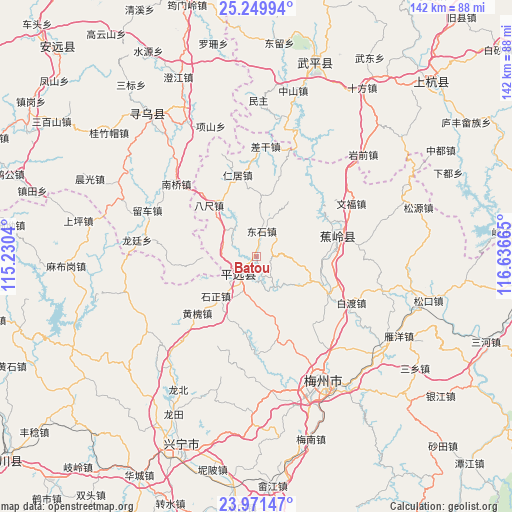
Batou GPS coordinates[2]
24° 36' 44.424" North, 115° 56' 0.672" East
| Map corner | latitude | longitude |
|---|---|---|
| Upper-left | 25.24994°, | 115.2304° |
| Center: | 24.61234°, | 115.93352° |
| Lower-right: | 23.97147°, | 116.63665° |
| Map W x H: | 142.2×142.2 km | = 88.4×88.4mi |
| max Lat: | 53.31946° ⇑88.1% North |
| Batou: | 24.61234° |
| min Lat: | ⇓11.9% South 18.22056° |
| min Long | Batou | max Long |
| 75.07348° | 115.93352° | 134.28917° |
| W 59.6%⇐ | ⇒40.4% E |
Elevation
Elevation of Batou is 144 m = 472 ft, and this is 340.8 m = 1118 ft below average elevation for this country.
| Max E: |
5622 m = 18445 ft | 52.9% |
| Avg. | 484.8 m = 1591 ft | |
| Batou | 144 m = 472 ft | |
Min E: |
-3 m = -10 ft | 47.1% |
See also: China elevation on elevation.city.
Geographical zone
Batou is located in North temperate zone (between Tropic of Cancer and the Arctic Circle). Distance of this Northern Tropic circle is 130.7 km =81.2 mi to South.| Distance of | km | miles | from Batou |
|---|---|---|---|
| North Pole | 7270.4 | 4517.6 | to North |
| Arctic Circle | 4664.5 | 2898.4 | to North |
| Tropic Cancer | 130.7 | 81.2 | to South |
| Equator | 2736.6 | 1700.4 | to South |


Nearby cities:
15 places around Batou: (largest is in red/bold)
• Bachi
19.4 km =12.1 mi,  317°
317°
• Changtian
16.2 km =10.1 mi,  168°
168°
• Chaozhu
9.1 km =5.7 mi,  202°
202°
• Danxi
16 km =9.9 mi,  268°
268°
• Dazhe
5.9 km =3.7 mi,  225°
225°
• Dongshi
7.5 km =4.7 mi,  11°
11°
• Hetou
9.7 km =6 mi, 321°
• Maoping
6.4 km =4 mi,  52°
52°
• Meixi
19.2 km =11.9 mi, 204°
• Rezhe
9.8 km =6.1 mi,  150°
150°
• Sanzhen
19.8 km =12.3 mi,  96°
96°
• Shangju
20.2 km =12.6 mi, 14°
• Shizheng
15.3 km =9.5 mi, 225°
• Sishui
18.3 km =11.4 mi,  30°
30°
• Zhongxing
12.6 km =7.8 mi,  296°
296°
Sources, notices
• [Note1] Compared only with cities in China existing in our database
• [Src1] Map data: © OpenStreetMap contributors (CC-BY-SA)
• [Src2] Other city data from geonames.org with taken over terms of usage.
• [Src3] Geographical zone / Annual Mean Temperature by Robert A. Rohde @ Wikipedia
