Sanzhen geodata
Sanzhen (Guangdong) is a seat of a fourth-order administrative division; located in China in Asia/Shanghai (GMT+8) time zone. In our database, there are 1268 cities with bigger population. Compared to other cities in China, 88.2% of cities are located further ↑North; 60.8% of cities are located further ←West and 61.5% of cities have higher elevation than Sanzhen. Note1


Sanzhen GPS coordinates[2]
24° 35' 29.436" North, 116° 7' 41.052" East
| Map corner | latitude | longitude |
|---|---|---|
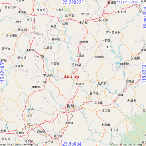
| Upper-left | 25.22922°, | 115.42495° |
| Center: | 24.59151°, | 116.12807° |
| Lower-right: | 23.95054°, | 116.8312° |
| Map W x H: | 142.2×142.2 km | = 88.4×88.4mi |
| max Lat: | 53.31946° ⇑88.2% North |
| Sanzhen: | 24.59151° |
| min Lat: | ⇓11.8% South 18.22056° |
| min Long | Sanzhen | max Long |
| 75.07348° | 116.12807° | 134.28917° |
| W 60.8%⇐ | ⇒39.2% E |
Elevation
Elevation of Sanzhen is 90 m = 295 ft, and this is 394.8 m = 1295 ft below average elevation for this country.
| Max E: |
5622 m = 18445 ft | 61.5% |
| Avg. | 484.8 m = 1591 ft | |
| Sanzhen | 90 m = 295 ft | |
Min E: |
-3 m = -10 ft | 38.5% |
See also: China elevation on elevation.city.
Geographical zone
Sanzhen is located in North temperate zone (between Tropic of Cancer and the Arctic Circle). Distance of this Northern Tropic circle is 128.4 km =79.8 mi to South.| Distance of | km | miles | from Sanzhen |
|---|---|---|---|
| North Pole | 7272.7 | 4519 | to North |
| Arctic Circle | 4666.9 | 2899.9 | to North |
| Tropic Cancer | 128.4 | 79.8 | to South |
| Equator | 2734.3 | 1699 | to South |


Nearby cities:
15 places around Sanzhen: (largest is in red/bold)
• Baidu
12.6 km =7.8 mi,  148°
148°
• Batou
19.8 km =12.3 mi,  276°
276°
• Changtan
9.8 km =6.1 mi,  14°
14°
• Changtian
21.3 km =13.2 mi,  230°
230°
• Dongshi
20.6 km =12.8 mi,  298°
298°
• Jiaocheng
8.3 km =5.2 mi,  28°
28°
• Lanfang
10.5 km =6.5 mi,  57°
57°
• Longwen
22.1 km =13.7 mi,  89°
89°
• Maoping
15.9 km =9.9 mi,  293°
293°
• Rezhe
16.2 km =10.1 mi,  247°
247°
• Shishan
16.6 km =10.3 mi,  194°
194°
• Sishui
20.7 km =12.9 mi,  330°
330°
• Wenfu
18.5 km =11.5 mi,  21°
21°
• Xinbu
8.9 km =5.5 mi,  182°
182°
• Xingfu
7.8 km =4.8 mi, 34°
Sources, notices
• [Note1] Compared only with cities in China existing in our database
• [Src1] Map data: © OpenStreetMap contributors (CC-BY-SA)
• [Src2] Other city data from geonames.org with taken over terms of usage.
• [Src3] Geographical zone / Annual Mean Temperature by Robert A. Rohde @ Wikipedia
